Mississippi Fishing Maps by Fishing Hot Spots are superb maps showing the lake bottoms for hundreds of lakes and rivers across the USA. These maps are printed on either kimdura or Hop-syn (both tear-resistent waterproof synthetic materials), making them nearly indestructible. The maps show lake bottom contours, shoreline features, roads leading to the lakes, boating facilities along the lake shore, and much more.
Fishing Map sample Enlargement
$13.95
62-7693-A267
Enid Lake fishing map.
$13.95
62-7693-A268
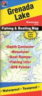
Grenada Lake fishing map.
$13.95
62-7693-A269
Ross Barnett Reservoir fishing map.
$13.95
62-7693-A270
Sardis Lake fishing map.
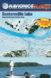
Navionics Fishing Maps. Using advanced computerized hydrographic survey technology, Navionics collected thousands of man-hours of data including water depth, lake bottom characteristics, sonar imagery and global positioning points for selected lakes across the country. The data, ranging from several hundred thousand to several million data points per map, is edited to create highly detailed lake bottom fishing maps.
Features of the lake maps.
Color shaded depth contours.
Major routes and highways.
Double-sided with detailed area insets.
Area points-of-interest.
Top-down satellite photo overlay.
Tear resistant.
3D lake overview.
Water resistant or water proof.
Measures approximately 24" x 36" - folds to small booklet size.
Most popular lakes have multiple sheets for the most detailed coverage.
Buy
Sample
Catalog #
Title
Price
62-76932-SA
Sardis Lake fishing map.
$19.99
Mississippi Fishing Maps by A.I.D. Assoc. These maps are well researched to show accurately underwater details, including ponds, creeks, ridges, valleys, trees, roads, and cemeteries. The maps are printed on waterproof synthetic material and have a 60-second latitude/longitude grid.
Full-color photographs and information on the map tell you what resorts, marinas, motels, bait and tackle stores, restaurants, and other businesses in the area have to offer and how to phone ahead for reservations.
Sample #1. Sample from the Belton-Stillhouse, Texas map.
Sample #2. Sample from the Fayette County, Texas map.
Sample #3. Sample from the Conroe, Texas map.
Sample #4. Sample from the Red River, Louisiana map.
$11.99
62-76931-EN
Enid/Granada fishing map. (on waterproof paper with GPS coords.).
$11.99
62-76931-RO
Ross Barnett fishing map. (on waterproof paper with GPS coords.).
$11.99
62-76931-SA
Sardis fishing map. (on waterproof paper with GPS coords.).
 Fishing Map sample
 Enlargement


 Sample #1.
 Sample #2.
 Sample #3.
 Sample #4.