Privacy statement - Your personal information, including e-mail address, is not sold, rented, or otherwise shared with anyone outside our small company.
Contact information. Includes contact e-mails, telephone and fax numbers, and mailing address.
U.S. Forest Service Maps
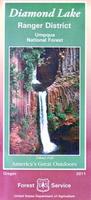
(OR) Diamond Lake Ranger District Map. 1:63,360. 2011. USFS.
High Cascades glaciation, whitewater rapids and explosive volcanic events have shaped the spectacular scenery and abundent natural resources of the Umpqua National Forest's Daimond Lake Ranger District. Waterproof, With contour lines.
62-89856
1 sheet, folded.
$14.99
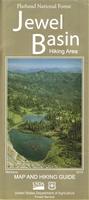
(MT) Jewel Basin Ranger District, Flathead National Forest Map. 1:42,240. USFS, 2015.
The Jewel Basin Hiking Area is a unique 15,000 acre hiking area maintained exclusively for hiking and camping. This high mountain area is popular for backpacking, fishing and plant and wildlife viewing. Water-resistant paper, 200-ft contour lines, and shaded relief.
62-78857
1 sheet, folded.
$14.99
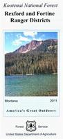
(MT) Kootenai National Forest Ranger District Maps. USFS.
Paper maps, with contour lines.
62-78887
Libby Ranger District Map. 1:50,688. 2011. ISBN 9781593510909.
$14.99
62-78888
Rexford and Fortine Ranger Districts Map. 1:50,688. 2011. ISBN 9781593510893.
$14.99
62-78889
Three Rivers Ranger District Map. 1:50,688. 2011. ISBN 9781593510916.
$14.99
Beartooth Publishing Maps
Beartooth Publishing publishes topographic trail maps and guidebooks designed for outdoors addicts. All of their maps are printed on waterproof, tear resistant plastic. They show national forest roads, trails, and recreation sites such as trailheads, campgrounds, picnic areas, and fishing access sites.
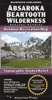
Absaroka Beartooth Wilderness Outdoor Recreation Map, Montana. 1:100,000. 2010. Beartooth Publishing.
This map includes the entire Abasaroka-Beartooth Wilderness from Livingston to Red Lodge, the northern section of Yellowstone National Park, the famous Beartooth Highway, and Paradise Valley. It combines and updates all or parts of 85 USGS 7.5 minute quads, and shows trail mileages. ISBN 9781887460095.
Sample detail from the Absaroka Beartooth Wilderness Map.
62-7871-AB
1 sheet, folded
$11.95
Beartooth Mountains Outdoor Recreation Map, Montana. 1:50,000. 2010. Beartooth Publishing.
This map is the back side of the Absaroka - Beartooth map listed above, enlarged to twice the scale. The map covers from Red Lodge to the border of Yellowstone National Park. It has color coded trails which show the recreational users allowed on each trail, and symbols showing which fish species are found in each Montana lake. ISBN 9781887460132.
Sample detail from the Beartooth Mountains Map.
62-7871-BE
1 sheet, folded
$11.95
Big Sky Outdoor Recreation Map, Montana. 1:50,000. 2010. Beartooth Publishing.
This map covers the Big Sky area from the Spanish Peaks to Yellowstone's Bighorn Pass Trailhead. The larger scale (two times the scale of the overview map listed below) is better for trail or backcountry use. It covers the Spanish Peaks and Monument Mountain Units of the Lee Metcalf Wilderness, most of the Taylor Hilgard Unit, and the northwest corner of Yellowstone. ISBN 9781887460095.
Sample detail from the Beartooth Mountains Map.
62-7871-BI
1 sheet, folded
$11.95
Bozeman Area Outdoor Recreation Map, Montana. 1:50,000. 2011. Beartooth Publishing.
This map covers just the Bozeman area from Sacagawea Peak to Hyalite Peak. The larger scale is better for trail or backcountry use. It covers the Bridger and Bangtail Ranges and the popular Hyalite area in the Gallatin Range. ISBN 9781887460224.
Sample detail from the Bozeman Area Map.
62-7871-BO
1 sheet, folded
$11.95
Bozeman - Big Sky - West Yellowstone Outdoor Recreation Map, Montana. 1:100,000. 2010. Beartooth Publishing.
This map covers a large section of the largest intact ecosystem left in the 'lower 48'. The map includes the western section of Yellowstone National Park, the Lee Metcalf Wilderness, the Bridger, Gallatin, Madison, and Henrys Lake Mountain Ranges, the Hyalite area, the Spanish Peaks, and the Gallatin Canyon. ISBN 9781887460057.
Sample detail from the Bozeman - Big Sky - West Yellowstone Map.
62-7871-BY
1 sheet, folded
$11.95
Crazy Mountains Outdoor Recreation Map, Montana. 1:50,000. 2010. Beartooth Publishing.
This island range in Southern Montana, north of the Absaroka and Beartooth Ranges, has about thirty peaks over 10,000 feet in elevation, most of them unnamed. The central, high elevation areas contain many alpine lakes, creeks, and small glaciers. The trails on the east side of the range, some of the most scenic trails in Southern Montana, are open to foot and horse travel only. On the west and north sides of the range there are many trails open to bicycles, and also several trails open to motorized travel. ISBN 9781887460170.
Sample detail from the Crazy Mountains Map.
62-7871-CR
1 sheet, folded
$11.95
Sedona Outdoor Recreation Map, Montana. 1:31,600. 2012. Beartooth Publishing.
The classic trails into the surrounding Red Rock Secret Mountain, Munds Mountain, and Sycamore Canyon Wilderness areas offer great hiking experiences. Outside the wilderness areas several new trails are being built every year, providing seemingly endless choices for hiking, mountain biking, and trail running. Although the trails are excellent, the real draw of Sedona has always been its unique, incredible scenery of red rock canyons, spires, and buttes. ISBN 9781887460026.
Sample detail from the Sedona Map.
62-54764
1 sheet, folded
$11.95
Superstition Wilderness Outdoor Recreation Map, Montana. 1:45,000. 2009. Beartooth Publishing.
The Superstition Wilderness, just outside of Phoenix, is a hikers and backpackers paradise, containing everything from desert canyons with haunting cliffs and spires to pine covered mountains. The contrast of desolate canyons and lush oasises of creeks, springs, and cottonwoods is staggering. ISBN 9781887460019.
Sample detail from the Superstition Wilderness Map.
62-54765
1 sheet, folded
$11.95
Tobacco Root Mountains Outdoor Recreation Map, Montana. 1:50,000. 2010. Beartooth Publishing.
The Tobacco Root Mountains, located between Bozeman and Butte, is one of the most scenic ranges in Montana. Everyone who recreates here immediately puts this range on their list of favorite places. From rolling sagebrush hillsides to rugged alpine peaks and lakes, the scenery is as varied as it is great. ISBN 9781887460163.
Sample detail from the Tobacco Root Mountains Map.
62-7871-TO
1 sheet, folded
$11.95
Wind River Range Outdoor Recreation Map. 1:100,000. 2010. Beartooth Publishing.
One of the most famous mountain ranges in the United States, the Winds often defy reason with their beauty. For decades this range has been a destination for backpackers and rock climbers from around the world. Anyone who knows the Winds will tell you that to truly experience the range, you must trek for two or more days into it. That is mostly true, but the cartographers have included descriptions for six of the Winds best dayhikes on this map for the day trekkers. Even for campers, you cant go wrong with the Winds.
This map covers the towns of Lander, Pinedale, and Dubois, and the Bridger, Fitzpatrick, and Popo Agie Wilderness Areas. All trailheads and access roads are also shown to get your trip started successfully. ISBN 9781887460156.
Sample detail from the Wind River Range Map.
Wind River Range North Outdoor Recreation Map. ISBN 9781887460200. This map covers the Northern Wind River Range from Pinedale to the Trail Lakes Trailhead south of Dubois.
$11.95
63-02771S
Wind River Range South Outdoor Recreation Map. ISBN 9781887460217. This map covers the Southern Wind River Range from Lander to the Fire Hole Lakes area.
$11.95
Denmark Cycling Maps
New series! Denmark Cycling Map Series. 1:100,000 & 1:50,000. 2015. Nordisk Korthandel, Denmark.
This new series will give complete coverage of Denmark in eight sheets. The maps are printed on paper and are a handy small format that fits in your bag, but it is big and wide when folded out.
New title! Djibouti Road Map. Ing. Houssein Ahmed Hersi, 2015. Approx. 1:300,000. A general physical and road map of the country of Djibouti, produced in Djibouti. Shaded relief and spot heights denote elevation. Symbols on the map locate tourist sites and services. There is a names directory and a mileage chart. See the Djibouti city map below for a map of the city.
Sample from the Djibouti city map.
64-47911
1 sheet, folded.
$24.99
New edition Djibouti City Map. Ing. Houssein Ahmed Hersi, 2015. Approx. 1:8,000. A detailed city street map of Djibouti. Folded, double-sided, in French. This is the most detailed street map of Djibouti that we have seen. EAC 0950528380292
Sample from the Djibouti city map.
Visiting North Carolina? Like to visit Omni? Please click here for a Mapquest map to our offices. If you are passing through central North Carolina, we would be pleased to have you visit our store and warehouse. We are located about 30 minutes east of Greensboro, 60 minutes west of Raleigh, and 2 hours northeast of Charlotte. We are open Monday-Friday 8am - 5:30pm and weekends by prior arrangement.

 Sample detail from the Absaroka Beartooth Wilderness Map.
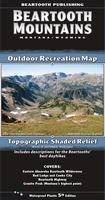
 Sample detail from the Beartooth Mountains Map.
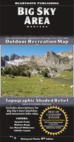
 Sample detail from the Beartooth Mountains Map.
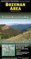
 Sample detail from the Bozeman Area Map.
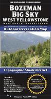
 Sample detail from the Bozeman - Big Sky - West Yellowstone Map.
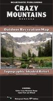
 Sample detail from the Crazy Mountains Map.
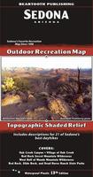
 Sample detail from the Sedona Map.
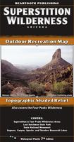
 Sample detail from the Superstition Wilderness Map.
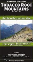
 Sample detail from the Tobacco Root Mountains Map.
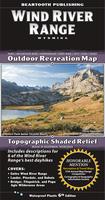
 Sample detail from the Wind River Range Map.
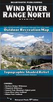
 Sample detail from the Wind River Range North Map.
 New series!
 Sample detail from the northern Zeeland cycling map.
 Sample detail from the southern Zeeland cycling map.
 Sketch map of map coverages
 New title!
 Sample from the Djibouti city map.
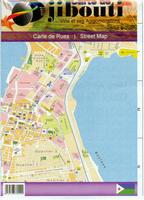 New edition
 Sample from the Djibouti city map.
 New title!
 Sample of the general Kigali city map.
 Sample of the tips noted on the Kigali map.
 Sample of the map legend from the Kigali map.
 Sample detail of the city center from the Kigali map.