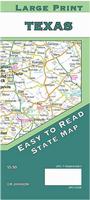
Roads of Texas atlas. 2017. Includes Information on Famous Texans;
Festival Information; Ghost Towns; Historic Forts & Missions; Longitude & Latitude Information; Mileage Chart; National & State Parks; Texas Counties Inset. ISBN 9780762591466. Spiral-bound, size is 10.875 x 14.875 inches.
New map! Michigan Breweries & Wineries Map. Kappa Map Group. 2017.
This guide includes a comprehensive directory of over 200 brewery locations and over 100 of the state's winery locations. the map includes insets covering fourteen urban areas. ISBN 9780762591473.
Sample detail of the map
Hiking maps for western Montana. Cairn Cartographics.
Cairn Cartographics produces excellent hiking/topographic maps for western Montana, covering ares for which there are no other detailed hiking maps. These include beautiful, and popular, hiking areas as the Bob Marshall Wilderness, Selway-Bitterroot, Glacier National Park, and the Mission Range.
Bob Marshall North hiking map. 1:80,000. Covers North half of The Bob Marshall Wilderness Complex, Entire Great Bear Wilderness, Jewel Basin Hiking Area, Swan Crest (Alpine Trail), and Badger/Two Medicine area.
Sketch map showing map coverage. Sample detail of the map
$15.95
62-7872-BMS
Bob Marshall South hiking map. 1:80,000. Covers South half of The Bob Marshall Wilderness Complex, Entire Scapegoat Wilderness, Seeley Lake area (east of highway 200), Rocky Mountain Front (near Augusta), Chinese Wall, and the South Fork Flathead River - Youngs/Danaher confluence to Black Bear cabin.
Sketch map showing map coverage. Sample detail of the map
Mission Range hiking map. 1:60,000. Covers Mission Range from Bigfork to the Jocko Road, Entire Mission Mountain Wilderness and Tribal Wilderness, Pistol Creek Area, and Seeley Lake Area west of Highway 83.
Sketch map showing map coverage. Sample detail of the map
$13.95
62-7872-RW
Rattlesnake Wilderness hiking map. 1:40,000 / 1:19,000. Covers Entire Rattlesnake Wilderness, Rattlesnake National Recreation Area, Pattee Canyon National Recreation Area, Blue Mountain National Recreation Area, Gold Creek area, and Missoula Open Space.
Sketch map showing map coverage. Sample detail of the map
$15.95
62-7872-SBN
Selway-Bitterroot North hiking map. 1:80,000. Covers North Half of the Selway-Bitteroot Wilderness, Highway 12: Lolo to Lowell, Montanas Bitterroot Valley: Lolo to Lost Horse, Selway River: Moose Creek to Lowell, and Bitterroot River: Wally Crawford Access to Lolo.
Sketch map showing map coverage. Sample detail of the map
$15.95
62-7872-SBS
Selway-Bitterroot South hiking map. 1:80,000. Covers South Half of the Selway-Bitteroot Wilderness, Magruder Corridor Road, Montanas Bitterroot Valley: Lost Horse to East/West Fork Bitterroot Jct., Selway River: Paradise Put-in to Race Creek Takeout, West Fork Bitterroot Area, and Blue Joint Area
Sketch map showing map coverage. Sample detail of the map
Pacific Crest Trail Guide
Trekking the Pacific Crest Trail. Cicerone Press, 2017.
This guidebook is a complete guide to hiking the Pacific Crest Trail (PCT), an epic 2650-mile hike along America's west coast. Frequently voted among the best hikes in the world, the route, which was created exclusively for backpackers and horse-riders, stretches from California's Mexican border to Canada's British Columbia. It boasts breathtaking scenery and varied landscapes, passing through California, Oregon and Washington State and taking in the Mojave desert, High Sierras, Cascades and countless more wild mountains.
Written with a relaxed pace in mind, this guide presents the full route in 101 sections of 2-3 days which can be combined into longer days according to ability and preference. Alongside the notes and route descriptions, there are overview maps for the entire trail, and a detailed introduction that provides essential advice for planning and completing the route. From information on packing, supplies, water and bears, to details on the mountains, wildlife and regions trekkers will go through, this is an essential companion to taking on - and completing - this once in a lifetime adventure.
Click here for the official maps for the Pacific Crest Trail.
$24.95
54-5980PC
Guide
Tennessee Fishing Maps by Fishing Hot Spots
Click here for all of our nearly 1000 fishing maps!
New edition Mt. Baker Ranger District Map. 1:63,360. U.S. Forest Service, 2017.
Totaling over 534,334 acres, the Mt. Baker Ranger District offers a diverse range of landscapes; snow covered peaks to remote valleys, mountain streams to misty lakes, forested slopes to alpine meadows. In the center towers Mt. Baker, a two-mile high, glacier-clad volcano. Waterproof, tear-resistant, with 100-foot contours.
$19.99
62-99775
1 sheet, folded.
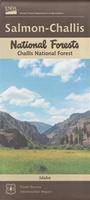
New edition Challis National Forest, Salmon-Challis National Forests Hiking Map. 1:126,720. U.S. Forest Service, 2017.
The combined Salmon and Challis National Forests offer nearly unlimited opportunities for hunting, fishing, hiking, and much more.
$19.99
62-64788
1 sheet, folded.
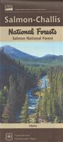
New edition Salmon National Forest, Salmon-Challis National Forests Hiking Map. 1:126,720. U.S. Forest Service, 2017.
The combined Salmon and Challis National Forests offer nearly unlimited opportunities for hunting, fishing, hiking, and much more. ISBN 9781628113006.
$19.99
62-64787
1 sheet, folded.
New edition Six Rivers National Forest Hiking Map. 1:126,720. U.S. Forest Service, minor revisions 2017.
With 1,500 miles of waterways, the Six Rivers area offers fantastic whitewater and river recreation opportunities. The combination of dramatic settings, water-based recreation opportunities, outstanding salmon and steelhead fishing, remoteness from major urban populations, and rich cultural heritage make the Six Rivers National Forest a perfect choice for every visitor. ISBN 9781628114256.
$14.99
62-56773
1 sheet, folded.
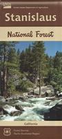
New edition Stanislaus National Forest Hiking Map. 1:126,720. U.S. Forest Service, 2017.
Nestled between Lake Tahoe and Yosemite National Park, the Stanislaus National Forest awaits you with its soaring crests, sparkling mountain lakes, towering forests and canyons carved by cool rushing rivers. Here you can cast for trout in over 800 miles of streams, kayak on a lake, raft a river, hike a wildflower strewn trail to find solitude and pristine conditions or simply relax in the majestic beauty of the breathtaking landscapes. ISBN 9781628114126.
$19.99
62-56774
1 sheet, folded.
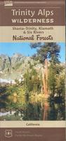
New edition Trinity Alps Wilderness Hiking Map. 1:63,360. U.S. Forest Service, 2017.
The Trinity Alps Wilderness is located in northwestern California west of Redding and east of Eureka. The Trinity Alps includes the head waters of the Trinity and Salmon rivers and is one of the largest parcels of backcountry land in the state growing to just over 515,000 acres.
$14.95
62-56806
1 sheet, folded.
Canada Hiking Maps
Click here for more maps for the Canadian Rockies!
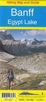
Banff and Egypt Lake Hiking Map. 1:50,000. Gem Trek.
Banff - Egypt Lake map covers the most popular hiking trails in the Banff area in four times as much detail as on our Banff-Mt. Assiniboine map.
Map coverage stretches from just east of Taylor Lake in the west to the west end of Lake Minnewanka in the east, and from Mystic Pass and Rockbound Lake in the north to Citadel Pass and Vermilion Crossing (Kootenay National Park) in the south.
All of the great day hikes in and around Banff townsite are covered on this map, including those to Tunnel Mountain, Sundance Canyon, the Spray River and Sulphur Mountain.
Sample detail from the Highland and Cataract Creek map. Thumbnail image of the Highland and Cataract Creek map.
$9.99
64-27902
1 sheet, folded.
Waterproof Highland and Cataract Creek Hiking Map. 1:50,000. Gem Trek. ISBN 9781895526066.
This is the fourth map in Gem Trek's Kananaskis Country series, covering south Kananaskis Country from Sheep River Falls in the north to Plateau Mountain in the south. On the back of the map are trail descriptions and photos of 18 recommended day hikes, two overnight trips and three classic mountain bike rides, plus contact information for visitor centres, campgrounds, hotels and lodges.
Sample detail from the Highland and Cataract Creek map. Thumbnail image of the Highland and Cataract Creek map.
$11.99
64-27922
1 sheet, folded.
Danube Hiking Guides by Cicerone Guides
The Danube Cycle Way Guide. Cicerone. 2016.
This two-volume set covers the entire Danube River. The first volume describes cycling the first 1270 km of the Danube river from its source in the Black Forest to Budapest, passing through Germany, Austria, Slovakia and Hungary. The second volume covers
the 1717 km route following the lower part of the Danube. This guidebook describes the route from the vibrant Hungarian capital of Budapest through Hungary, Croatia, Serbia and Romania to the river's delta on the shores of the Black Sea.
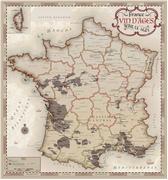
New title! France Wine of Ages Map. Vinmap.
Let your eyes wander throughout our antique, old world styled map that is steeped in a rich, complex history. This unique and one of a kind work of Cartographic Art is a perfect gift for the wine connoisseur or a fine addition to your wine cellar, living space or place of business.
Map size is 28? x 30?.
Sample detail from the France Wine of Ages map.
France Hiking and Cycling Guides by Cicerone Guides
Cycling the Canal du Midi Guide. Cicerone. 2017.
A guidebook to cycle touring along the Canal du Midi in the sunny Languedoc region of southern France. The 240km main canal route, and the 37km Narbonne extension are described. Information is also given on short detours to sights close to the canal, and longer excursions into the surrounding countryside. Also listed are the four 1:100,000 maps recommended by the author.
$24.95
64-56981CC
Guide.
Recommended Maps: 1:100,000 Cycling Maps.
$13.99
64-5652-168
IGN Sheet 168. Toulouse - Pamiers cycling map.
$13.99
64-5652-169
IGN Sheet 169. Beziers - Castres cycling map.
$13.99
64-5652-170
IGN Sheet 170. Montpellier - Nimes cycling map.
$13.99
64-5652-174
IGN Sheet 174. Beziers - Perpignan cycling map.
River Rhone Cycling Guide - from the Alps to the Mediterranean. Cicerone Press, 2017.
The River Rhone Cycle Route, an 895km bicycle ride starting high in the Alps of central Switzerland and finishing at the Mediterranean Sea, near Marseille.
The guide provides detailed route descriptions and 1:150,000 mapping for each stage, together with plenty of practical advice such as preparing for the journey, transport options there and back, what to take, accommodation en route and more. A Swiss/French glossary is also included.
Sketch map showing the cycling route.
$24.95
64-56985R
Guide
New edition Trekking the Vosges & Jura. Cicerone Press, 2017.
Guidebook to a 687km (427 mile) trek through eastern France, traversing the Vosges and the Haut-Jura plateau. The route follows the GR53 from Wissembourg to Schirmeck, before picking up the central section of the GR5 from Schirmeck to Nyon on Lake Geneva, taking in wooded and grassy hills, river gorges and fascinating castle ruins.
Click here for the famous Tabacco hiking maps for the Dolomites.
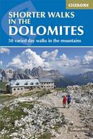
Shorter Walks in the Dolomites Hiking Guide. Cicerone. 2016.
Guidebook to day walks in the Italian Dolomites. The 50 graded walks range from short leisurely strolls to full-day high mountain expeditions, each designed to fit into a single day. The Dolomites are an ideal walking destination from June to September, and can easily be reached from Verona, Treviso, Venice and Innsbruck airports.
Sketch map showing the areas covered by the guide
$24.95
64-82961SD
Guide.
Walking in the Dolomites Hiking Guide. Cicerone. 2017.
This guide leads you through breathtaking alpine scenery flanked by well-graded paths and excellent mountain refuges that verge on hotels, which are easily accessible with the excellent network of public transport from major towns and travel hubs, such as Venice, Verona, Munich and Innsbruck.
Sketch map showing the areas covered by the guide
$27.95
64-82961DO
Guide.
Netherlands Cycling Atlas
Netherlands Cycling Atlas. 1:75,000. Falk.
The atlas includes:
Comprehensive spiral-bound atlas
Netherlands cycle route network and Rural Cycle Routes (LF routes)
With useful information about campsites, ferry services, etc.
In Dutch only!
$24.99
65-05835
Set.
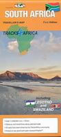
South Africa
New South Africa Road Map. 1:1,000,000. Track4Africa, 2015.
The map scale is 1:1,000,000 which gives you enough detail but also allows for an overview of the country. The map shows distances and drive times along nearly all of the roads on the map. The map is printed on PolyArt which is tear and water resistant and will survive your adventures with you. The South Africa map also includes Lesotho and Swaziland. ISBN 9780986987670.
Sample detail of the South Africa road map.
$26.99
65-30908
1 sheet, folded.
Switzerland Hiking Guides by Cicerone Guides
Swiss Alpine Route - Via Alpina 1 Hiking Guide. Cicerone. 2017.
This guidebook presents the stunning Alpine Pass Route, a 225 mile long-distance trail that traverses Switzerland from east to west, from Sargans to Montreux on Lake Geneva (Lac Léman).
$27.95
65-39971AP
Guide.
Recommended Maps: 1:50,000 Hiking Maps.
$29.99
65-39530237T
Walenstadt hiking map.
$29.99
65-39530238T
Montafon hiking map.
$29.99
65-39530245T
Stans hiking map.
$29.99
65-39530246T
Klausenpass hiking map.
$29.99
65-39530247T
Sardona hiking map.
$29.99
65-39530255T
Sustenpass hiking map.
$29.99
65-39530262T
Rochers de Naye hiking map.
$34.99
65-3952-5004
Berner Oberland topo map. Sheet 5004.
$34.99
65-3952-5009
Gstaad - Adelboden topo map. Sheet 5009.
World Upside Down Wall Maps
"Upside Down" World Map. ODT.
This map has the world turned upside down to give a different perspective on the world. The map has shaded relief to show mountain ranges; each country is colored differently and the map has several comparative world views along the bottom. Available either flat/rolled or as a laminated wall map.
Available in two sizes is 24 x 36" and 36 x 56".
Thumbnail image of whole map A detail from the map
$16.99
67-1113
24 x 36", flat/rolled map, paper.
$29.99
67-1113L
24 x 36", laminated
$20.00
67-1111
36 x 56", folded
World Peters Projection (Equal Area) World Wall Maps
World Peters Projection Map. ODT.
The Peters Projection World Map is one of the most stimulating, and controversial, images of the world.
When this map was first introduced by historian and cartographer Dr. Arno Peters at a Press Conference in Germany in 1974 it generated a firestorm of debate and it continues to have passionate fans as well as staunch detractors, as noted in its portrayal on The West Wing tv show.
The earth is round. The challenge of any world map is to represent a round earth on a flat surface. There are literally hundreds of map projections. Each has certain strengths and corresponding weaknesses. Choosing among them is an exercise in values clarification: you have to decide what's important to you. That is generally determined by the way you intend to use the map. The Peters Projection is an area accurate map, meaning the sizes of each land mass is accurate in relation to each other.
Size is 24 x 36".
$15.99
67-10511SF
Folded map, paper. 24 x 36"
$19.99
67-10511S
Wall map, paper. 24 x 36"
$24.99
67-10511SL
Laminated wall map. 24 x 36"
World Desk Pad
Back in stock! World Desk Pad. 1:60,000,000. Maps International.
World map with topographical features and a political overlay showing countries, states, cities, rivers, mountains, and lakes turned into a handy desk pad. Desk pad size is 24.75 x 16.5 inches.
Visiting North Carolina? Like to visit Omni? Please click here for a Mapquest map to our offices. If you are passing through central North Carolina, we would be pleased to have you visit our store and warehouse. We are located about 30 minutes east of Greensboro, 60 minutes west of Raleigh, and 2 hours northeast of Charlotte. We are open Monday-Friday 8am - 5:30pm and weekends by prior arrangement.
Contact information: For information on a map or other product: [email protected] To place an order or check on an order: [email protected] For questions on an invoice: [email protected] Phone: (1) 336-227-8300
Fax: (1) 336-227-3748
 New title
 Sample detail from the Texas road map.
 Front of the Texas road map.
 Reverse of the Texas road map.
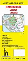
 Sample detail from the Harrisburg street map.
 Front of the Harrisburg street map.
 Reverse of the Harrisburg street map.
 Sample detail from the Roads of Texas atlas.
 New map!
 Sample detail of the map
 Sample detail of the Wisconsin road map
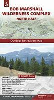
 Sketch map showing coverage of six of the eight Cairn Carto. maps.
 Sketch map showing map coverage.
 Sample detail of the map
 Sketch map showing map coverage.
 Sample detail of the map
 Sketch map showing map coverage.
 Sample detail of the map
 Sketch map showing map coverage.
 Sample detail of the map
 Sketch map showing map coverage.
 Sample detail of the map
 Sketch map showing map coverage.
 Sample detail of the map
 Sketch map showing map coverage.
 Sample detail of the map
 Sketch map showing map coverage.
 Sample detail of the map
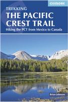
 New editions
 The front of the Dale Hollow fishing map.
 The reverse of the Dale Hollow fishing map.
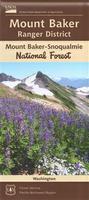 New edition
 New edition
 New edition
 New edition
 New edition
 New edition
 Sample detail from the Highland and Cataract Creek map.
 Thumbnail image of the Highland and Cataract Creek map.
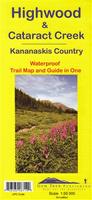 Waterproof
 Sample detail from the Highland and Cataract Creek map.
 Thumbnail image of the Highland and Cataract Creek map.
 New title!
 Sample detail from the France Wine of Ages map.
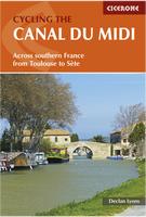

 Sketch map showing the cycling route.
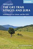 New edition
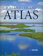
 Sample detail of a road map page from the Iceland road atlas.
 Sample detail of a city map page from the Iceland road atlas.
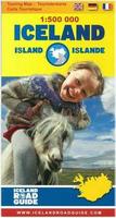
 Sample detail of the Iceland road map.
 Sample detail of the legend of the Iceland road map.
 Sketch map showing the areas covered by the guide
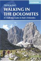
 Sketch map showing the areas covered by the guide

 New
New
 Sample detail of the South Africa road map.
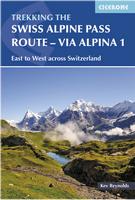


 Thumbnail image of whole map
 A detail from the map
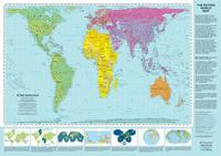 World Peters Projection Map. ODT.

 Back in stock!
 Image showing the foam backing on the desk pad.
 Image showing the foam backing on the desk pad.