We stock a huge selection of World Maps, from room-sized wall maps to specialty maps such as World of Coffee maps and the geology map listed below. Please click here to see our complete list of World Maps.
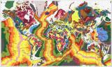
World Geologic Map. 1:25,000,000. CGMW, Paris, 2000. A more detailed world geologic map than the Open University map listed elsewhere on our web site. More applicable to university and research insititutions and practicing geologists. This second edition has been entirely revised in order to show a clear distinction between sedimentary, volcanic extrusive, and endogenous dated formations. The geology of the oceans has been
updated according to the most recent magnetic and satellite-gravimetric data. Positions of the main volcanoes and meteoritic craters were added to the map. The new cartographic conception of the map allows a rapid visual reconstruction of the main plates and subplates of the global tectonics. Available in three versions; paper, Arc Info® cd-rom (for professional users), or GeoKiosk® cd-rom (for non-professional users). The GeoKiosk version is now out of print and available only as long as our supplies last. Assembled size is 196 x 100 cm (approx. 77 x 39").
Thumbnail of the map. Sample detail of the map.
67-1001
3 sheets, rolled
$54.99
67-1001A
ArcInfo format®
$234.95
67-1001G
GeoKiosk®. While supplies last.
$70.00
67-1001C
GeoKiosk® + printed map. Note: Does not run on Windows XP.
$99.95
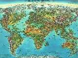
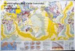
World Geologic Map. Open University, U.K. An excellent single-sheet geologic map of the world. Less detailed, and less expensive, than the map above, this map is ideal for classrooms, laboratories, or meeting rooms. Map size is 40 x 60 inches.
Thumbnail of the entire map Legend of the map
67-10015
1 sheet, rolled
$9.95
67-10015-10
10 copies, rolled - Save 25%!
$74.65
67-10015L
Laminated
$32.95
World Sedimentary Provinces Map. AAPG. 1984. Shows sedimentary accumulations more than 1000 meters thick. With 36-page booklet.
67-1006
Set
$29.95
World Environments During the Last Two Climatic Extremes. 1:50,000,000. CGMW. 3rd ed., 2006. Two maps. Map 1 is the Last Glacial Maximum (ca 18,000 yrs. B.P.) and Map 2 is the Holocene Optimum (ca 8,000 yrs. B.P.).
The time slices considered in this work correspond to average temperatures of the surface of the Earth 4.5C lower and 2C higher than present temperatures. This is the first time that a reconstruction of the environment is made
using multidisciplinary data of the recent Quaternary. This preliminary attempt provides a serious base for ongoing reflections about the planet's warming due to the increase of the greenhouse effect caused by human activities, and that can be usefully compared
to existing modelisations. Available in either a paper edition or an ArcView digital edition.
Sample detail of the map.
67-10370
Paper edition
$37.95
67-10371
in ArcInfo format + paper map.
$84.95
Clearance sale! World Atlas of Resources and Environment (Prioda i resursy Zemii). RAN, Vienna, 1998. This excellent atlas contains two volumes, divided into four major sections; I: The Earth and Space; II: Evolution of the Landscape Sphere; III: Landscape Sphere - Structure and Resources; IV: Anthropogenic Factors of Landscape Sphere Changes.
There are 190 thematic maps (1:6,000,000 to 1:300,000,000), many of which are fold-out maps. Each map sheet has comments on the reverse as well as graphs, tables, etc. In English with Russian titles. Size is 35 x 49 cm, clothbound with screws and slipcase.
61-0800
Atlas.
$49.95
World Orographic Map. 1:15,000,000.
67-1028
$24.95
World Coconuts and Oil Palms: World Production and Consumption. 1:40,000,000. OSD (3275). 1992.
67-1065
1 sheet, rolled
$5.95
Mineral Atlas of the World - sheet 9: Europe and Neighboring Countries. 1:10,000,000. CGMW/NGU co-publication, 2000. This is the first published sheet of a series entitled Mineral Atlas of the World that follows the same map assemblage pattern as the Geological Atlas of the World. This sheet covers the area comprised between the Atlantic Ocean to the Urals,
the Near East and part of North Africa included, depicts mineral deposits of about 50 countries, and identifies 760 mineral deposits, a list of which is given on the left side of the map. Bilingual French/English, sheet size 96 x 60 cm.
67-10401-09
1 sheet, rolled
$52.95
67-10401-09D
Atlas.
$40.00
World Earthquake and Seismicity Maps
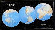
World Seismicity Poster: 1979-1988. USGS. This poster (64 x 36") displays selected hypocenters for earthquakes that occurred during 1979-1988.
More than 23,000 separate epicenter locations, representing 97,069 earthquakes, are displayed. The base map is Raven Maps' famous "Three Worlds" map.
67-3208
Each, rolled
$19.99
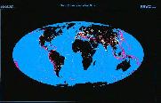
Global Seismicity and World Cities. USGS. This map (53 x 34.5") displays the worldwide hazard to cities posed by large earthquakes.
When earthquakes occur near cities of any size, the potential for damage is great. On this map more than 39,000 earthquake epicenters (purple dots) are depicted.
Where earthquake epicenters are co-located with cities, the earthquake epicenters are denoted by orange dots. Base map from Raven Maps.
67-3205
Each, rolled
$14.95
A Century of Great Earthquakes: 1897-1996. USGS. This map (27 x 18") sohws selected earthquakes having a determined magnitude of 7.8 or greater.
Portions of the Southwest and North Pacific are not included, even though they may have experienced great earthquakes. The base map is from Unique Media.
67-3209
Each, rolled
$14.95
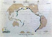
Circum-Pacific Seismic Potential. USGS. The map (35 x 26") shows the time-dependent probabilities for the recurrence of large (7.07.7) shallow, plate-boundary earthquakes within specified segments of the Circum-Pacific region. The time window depicted is 1989-1999. Base map is from Raven Maps.
67-3210
Each, rolled
$14.95
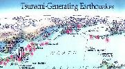
Tsunami-Generating Earthquakes. USGS. This map (27 x 18") shows those earthquakes that occurred in 1900-1994 that generated destructive tsunamis somewhere in the Pacific region.
Many of the earthquakes shown denerated tsunamis that resulted in loss of life. Tsunamis that originated from distant earthquakes are also shown on the map. Base map from Unique Media.
 Thumbnail of the map.
 Sample detail of the map.
 Thumbnail of the entire map
 Legend of the map
 Sample detail of the map.