Downloadable digital maps! Trinidad & Tobago Digital Road Map. 1:150,000. Reise Know-How. This map combines topographic mapping with road and tourist detail. The road information is clear and elevation is shown using contours, spot heights and altitude shading. The map shows six different types of roads, highlighting scenic routes, places of interest, archaeological sites, monasteries, monuments and viewpoints.
Digital versions available for immediate download! Digital versions are available for Compe-GPS, OziExplorer, and Touratech-Quo Vadis, for use with a PocketPC or a PC.
NOTE: You must own/obtain the basic software program for any of these packages - these maps do not come with run-time software. You only need to acquire the software once; additional Reise maps do not require additional copies of the software.
66-01901C
Immediate download digital version for Compe-GPS.
$21.99
66-01901O
Immediate download digital version for OziExplorer.
$21.99
66-01901T
Immediate download digital version for Touratech QV.
$21.99
Paper Trinidad & Tobago Road Maps
Waterproof! Trinidad & Tobago Road Map. 1:150,000. Reise Know-How. This is the first new map of Trinidad & Tobago since 1995. The map has clear cartography, altitude coloring to indicate elevation and contours at 100m intervals. It's special features include 6 road classifications, subtle overprints of nature reserves, wild life sanctuaries and other places of interest, a clear index and, for GPS users, UTM & longitude & latitude grids. German with English legend.
66-01901
1 sheet, folded
$15.99
Trinidad & Tobago Travel Map. ITMB, 2011. Nowadays, both islands are tourist havens, with delightful caves to explore on Trinidad and scuba diving on Tobago. This is a very detailed map, printed on paper, single-sided. Map size: 27"X39"
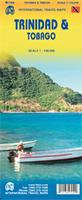
Sample detail of the Trinidad & Tobago Travel Map
66-01906
1 sheet, folded.
$12.95
Trinidad Road Map. 1:150,000. Lands and Survey Department, Trinidad & Tobago. Edition 5, 1990. A good road map of the island. Note: out of stock and a long delay before new stock arrives.
66-0190
1 sheet, folded
$11.95
Tobago Road Map & Guide. Approx. 1:35,000. Skyviews. 14th ed., 2010/2011. The map is a pocket tourist map, not a topographic or detailed physical map, but it is excellent at what it does. The map shows Tobago on the front with inset maps of Crown Point and Scarborough. The reverse has extensive tourist information ranging from accomodations to car/taxi rental to shopping and services. A folded pocket version and a laminated flat version are available; the laminated version is ideal as a souvenir placemat. Size is 24 x 18 inches.
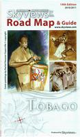
Sample detail from the Tobago road map. Image of the entire Tobago road map.
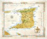
66-01905
1 sheet, folded.
$6.99
66-01905L
1 sheet, laminated.
$10.99
Tobago Road Map. 1:50,000. Lands and Survey Department, Trinidad & Tobago. Edition 2, 1991. A good road map of the island. Note: out of stock and a long delay before new stock arrives.
66-0191
1 sheet, folded
$11.95
Port of Spain City Map. 1:10,000. Trinidad & Tobago Lands & Surveys Division, ed. 7, 2001. This is a standard city street map. Note: out of stock and a long delay before new stock arrives.
66-0192P
1 sheet, folded.
$10.95
San Fernando Disaster Response Map. 1:12,500. Trinidad & Tobago Lands & Surveys Division, 1993. This is a standard city street map with colored symbols locating such places as police stations, hospitals, shelters, church shelters, health centers, areas subject to flooding, landslide hazard areas, evacuation routes, and much more. This map works as a city street/tourist map as well as a hazards map. Note: out of stock and a long delay before new stock arrives.
66-0192S
1 sheet, flat.
$10.95
Arima City Map. Lands and Survey Department, Trinidad & Tobago. Note: out of stock and a long delay before new stock arrives.
66-0192A
Arima Borough. 1:10,000. 1991.
$10.95
Trinidad General Map. 1:75,000. Lands and Survey Department, Trinidad & Tobago. Four sheets offer complete coverage.
66-0150
4 sheets, rolled
$36.95
Tobago antique-style wall map. 24 x 18".
Tobago is the smaller of the two main islands that make up the Republic of Trinidad and Tobago. The principal economic forces in Tobago are tourism and ecotourism that is focused on the large area of protected forest in the centre and north of the main island and on Little Tobago, a small island off the north east tip of the main island. Tobago has some of the best diving sites in the Caribbean.
66-01471
1 sheet, rolled.
$25.00
66-01471D
Deluxe frame
$275.00
66-01471S
Standard frame
$199.95
Trinidad antique-style wall map. 24 x 18".
Trinidad is the largest and most populous of an archipelagic republic in the southern Caribbean which consists of 23 distinct islands. Today's Trinidad is a diverse island of many different cultures and beautiful natural features that include a variety of beaches, seasonal tropical forests, and the hills of the Northern Range.
66-01472
1 sheet, rolled.
$25.00
66-01472D
Deluxe frame
$275.00
66-01472S
Standard frame
$199.95
Trinidad & Tobago Rough Guide Rough Guides. The Rough Guide to Trinidad and Tobago is the definitive guide to the most exciting and unexplored of the Caribbean islands. The full-colour section introduces the islands' diverse highlights from tropical bird watching in Northern Trinidad and the secluded wave-whipped sand at Tobago's Pirates bay, to hiking in the forested peaks of the Northern range.
66-0195RG
Guide
$19.99
Topographic Maps
Trinidad Topographic Quadrangle Map. 1:25,000. 1966-1977. DOS (316), Britain. Only partial coverage is still available. Note that sheets 33, 34, 35, 36, 43, 44, 45, 46 are partially covered by sheets from the old edition series, sheets #12, 13, 14, 15. These four sheets are listed at the
end of the sheet list. See the index (click on the index button below) to see the available coverage.
Sample
66-0151-03
Trinidad 1:25,000 topo #3
$18.95
66-0151-04
Trinidad 1:25,000 topo #4
$18.95
66-0151-05
Trinidad 1:25,000 topo #5
$18.95
66-0151-06
Trinidad 1:25,000 topo #6
$18.95
66-0151-11
Trinidad 1:25,000 topo #11
$18.95
66-0151-12
Trinidad 1:25,000 topo #12
$18.95
66-0151-13
Trinidad 1:25,000 topo #13
$18.95
66-0151-14
Trinidad 1:25,000 topo #14
$18.95
66-0151-15
Trinidad 1:25,000 topo #15
$18.95
66-0151-16
Trinidad 1:25,000 topo #16
$18.95
66-0151-23
Trinidad 1:25,000 topo #23
$18.95
66-0151-24
Trinidad 1:25,000 topo #24
$18.95
66-0151-25
Trinidad 1:25,000 topo #25
$18.95
66-0151-26
Trinidad 1:25,000 topo #26
$18.95
66-0151-53
Trinidad 1:25,000 topo #53
$18.95
66-0151-54
Trinidad 1:25,000 topo #54
$18.95
66-0151-55
Trinidad 1:25,000 topo #55
$18.95
66-0151-56
Trinidad 1:25,000 topo #56
$18.95
66-0151-62
Trinidad 1:25,000 topo #62
$18.95
66-0151-63
Trinidad 1:25,000 topo #63
$18.95
66-0151-64
Trinidad 1:25,000 topo #64
$18.95
66-0151-65
Trinidad 1:25,000 topo #65
$18.95
66-0151-66
Trinidad 1:25,000 topo #66
$18.95
66-0151-70
Trinidad 1:25,000 topo #70
$18.95
66-0151-71
Trinidad 1:25,000 topo #71
$18.95
66-0151-72
Trinidad 1:25,000 topo #72
$18.95
66-0151-73
Trinidad 1:25,000 topo #73
$18.95
66-0151-74
Trinidad 1:25,000 topo #74
$18.95
66-0151-75
Trinidad 1:25,000 topo #75
$18.95
66-0151-76
Trinidad 1:25,000 topo #76
$18.95
66-0151A-12
Trinidad 1:25,000 topo #12, old edition
$18.95
66-0151A-13
Trinidad 1:25,000 topo #13, old edition
$18.95
66-0151A-14
Trinidad 1:25,000 topo #14, old edition
$18.95
66-0151A-15
Trinidad 1:25,000 topo #15, old edition
$18.95
66-0152
Set of 30 sheets
$450.30
Tobago Topographic Map. 1:25,000. 1963. DOS (307), Britain. Three sheets offer complete coverage; only two sheets are still available as sheet 1 is out of print.
66-0153-1
Sheet 1 - southern Tobago. Color plot.
$18.95
66-0153-2
Sheet 2 - central Tobago
$18.95
66-0153-3
Sheet 3 - northern Tobago
$18.95
Digital Files
66-0153-1D
Sheet 1 - southern Tobago. Color plot.
$
66-0153-2D
Sheet 2 - central Tobago
$
66-0153-3D
Sheet 3 - northern Tobago
$
Tobago Topographic Quadrangle Map. 1:10,000. 1962-1963. DOS (207), Britain. This 19-sheet series offers complete coverage of Tobago.