|
|
Suriname Topographic Maps
Suriname Topographic Quadrangle Maps. 1:50,000. Centraal Bureau Luchtkartering. 1980- continuing series. We just received new stock of these maps. We also received a sizable quantity discount, allowing us to lower the price significantly. The 240+ sheets offer about 65% coverage of Suriname; primarily the northern inhabited areas. A few new sheets continue to be published each year. Black/white maps; "neodruk" sheets are photo-print black/white maps while "lichtdruk" are blueprint-type black/white maps. In Dutch. Standing orders are welcome. When ordering individual sheets, please put the sheet numbers needed in the "Comments" field of the order form.
Suriname Flags
|
|||||||||||||||||||||||||||||||||||||||||||||||||||||||||||||||||||
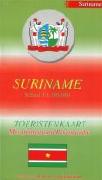
 Suriname Maps
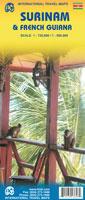


 Suriname Flags