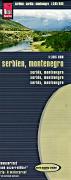
Waterproof! Serbia & Montenegro Travel Map. 1:385,000. Reise Know-How.
Detailed road map with contour lines and spot heights to show elevation. Printed on waterproof and tear-resistant synthetic paper. Multilingual.
65-94901
1 sheet, folded
$15.99
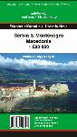
Serbia & Montenegro & Macedonia Map. 1:600,000. Szarvas/Hibernia Nova.
A detailed physical road map of Serbia, Montenegro, and Macedonia. Includes city inset maps, GPS coordinates, and index to place names. Multilingual.
65-94903
1 sheet, folded.
$12.99
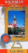
Serbia & Montenegro Travel Map. 1:500,000. GiziMap, Budapest.
GiziMaps are attractive, shaded relief or vegetation-shaded maps with good road and cultural information. Multilingual legend and map.
65-9490
1 sheet, folded
$14.99
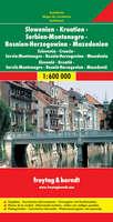
Serbia, Slovenia, Croatia, Bosnia, Herzegovina, Macedonia, and Montenegro Travel Map. 1:600,000. Freytag & Berndt.
This detailed road map covers all of the former Yugoslavia. Shaded relief shows elevation, roads are clearly marked, and tourist sites and services are marked. Multilingual legend, including English.
65-5690F
1 sheet, folded
$14.99
Serbia & Montenegro Road Map. 1:700,000. Intersistem Kartografija, Belgrade.
A basic road map of Serbia and Montenegro, produced by a Serbian company. With a bilingual index.
65-94902
1 sheet, folded.
$13.95
Serbia City Maps
Belgrade Street Atlas. 1:20,000. Intersistem Kartografija, Belgrade.
Spiral-bound street atlas. Indexed, bilingual index.
65-9492BI
Atlas.
$16.95
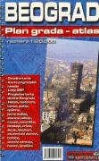
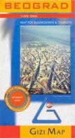
Belgrade City Map. 1:20,000. GiziMap, Budapest.
This map covers all of Belgrade with an inset map at 1:15,000 covering the city center. Streets, railways and administrative boundaries are indicated, and public buildings, parks, forests and cemetaries are distinguished from the rest of the built-up areas. Numerous symbols indicate churches, mosques, synagogues and tourism features such as museums, post offices, campsites etc. The index on the reverse of the map includes streets and those features symbolized on the map. Size is 36 x 27 inches unfolded.
Sample detail from the Belgrade map Sketch map showing area covered by this map.
65-9492BG
1 sheet, folded
$14.99
65-9492BGR
1 sheet, flat version
$19.99
65-9492BGL
Laminated
$36.99
Belgrad wall map. 1:15,000. Intersistem Kartografija, 2004.
A wall map, printed on heavy paper, with light-weight plastic hanging strips on top and bottom. In Serbian.
65-5692BF
1 sheet, rolled.
$49.95
Serbia City Street Maps. Intersistem Kartografija, Belgrade. Detailed city street maps, fully indexed. Usually bilingual Serbo-croat and English.
65-5692BH
Belgrade. 1:20,000. 2004.
$15.95
65-9492CA
Cacek. 1:8,000.
$9.95
65-9492CU
Cuprija. 1:10,000.
$9.95
65-9492KS
Kraljevo. 1:14,000.
$9.95
65-9492NJ
Nis. 1:10,000.
$9.95
65-9492NP
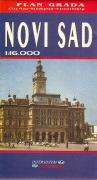
Novi Sad. 1:16,000.
$12.95
65-9492PB
Paracin. 1:8,000.
$9.95
65-9492PO
Pozarevac. 1:14,000.
$9.95
Serbia Hiking Maps
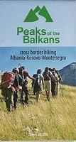
Peaks of the Balkans Trail Map. 1:60,000. Huber Verlag.
The transnational "Peaks of the Balkans Trail" guides through some of the most out of the way and wild mountain areas of the western Balkans. The "Peaks of the Balkans" walking map showing the trail through the mountains in the border region of Albania, Kosovo, Montenegro, and contains a detailed description of the various parts of the route including elevation profiles. Scale 1:60,000.
Sketch map of the hiking trail
65-5688740906
1 sheet, folded
$25.99
Durmitor and Tara Canyon, Durmitor National Park, Hiking Map. 1:25,000. Geokarta, Serbia, 2007.
This detailed hiking map includes full topographic information (contour lines, spot heights, vegetation shading, etc.), hiking trails, etc. Includes information on 27 marked walking tours, and has some bilingual Serbian/English tourist information on the reverse of the map.
Sample of the Durmitor hiking map detail Image of the entire Durmitor hiking map
65-88750
1 sheet, folded.
$19.99
Kopaonik National Park Tourist Map. 1:40,000. Geokarta d.o.o. 2008.
Mountain range in central Serbia and northeast Kosovo. Area covered by map, Pristina in south, Kraljevo in north, Novi Pazar in west and Nis in east. ISBN 9788645901401.
65-94725
1 sheet, folded.
$19.99
Suva Planina National Park Hiking Map. 1:55,000. Geokarta, Serbia, 2007.
This detailed hiking map has a topographic map marked with footpaths, ski trails, ski lifts, camp sites, picnic sites, mountain huts, also notable features in the landscape. The reverse side has tourist information and pictures about notable landscape features in the region. Bilingual Serbian/English.
Image of the entire Suva Planina hiking map.
65-9474
1 sheet, folded.
$19.99
Tara National Park Hiking Map. 1:50,000. Geokarta, Serbia, 2009.
Tara Mountain, part of the Outer Dinaric Alps, is located in western Serbia and stands at 1,000-1,500 meters above sea level. The mountain's slopes are clad in dense forests with numerous high-altitude clearings and meadows, steep cliffs, deep ravines carved by the nearby Drina River and many karst (limestone) caves. The mountain is a popular tourist center. Tara's national park encompasses a large part of the mountain. The main map has a detailed topographic map with hking information overprinted while the reverse side has bilingual tourist information and photos plus a small city-center map of Bajina Basta (in cyrillic).
Sample of the Tara hiking map detail
65-9475
1 sheet, folded.
$19.99
Serbia Hiking Maps City Street Map. Geokarta.
These are new hiking maps covering popular areas in Serbia and Montenegro. These are full-color topographic maps with hiking trails and roads overprinted. The maps have contours lines, plus spot heights and some with shaded relief.
Sample detail from the Serbia hiking maps
65-94700-BJ
Bjelasica Komovi hiking map. 1:60,000. Descriptive text in Serbian only.
$19.99
65-94700-DIV
Divcibare hiking map. 1:5,500. A satellite map of this popular resort location. Descriptive text in English/cyrillic.
$19.99
65-94700-FRU
Fruska Gora hiking map. 1:60,000. Descriptive text in Serbian only.
$19.99
65-94700-GOL
Golije Mtns. hiking map. 1:50,000. Excellent map of this famous Biosphere Preserve. Descriptive text in English/Serbian.
$19.99
65-94700-RAD
Radan Mtns. hiking map. 1:50,000. Descriptive text in English/Serbian.
$19.99
65-94700-RAJ
Rajac hiking map. 1:25,000. Descriptive text in English/Serbian.
$19.99
65-94700-VAL
Valjevska Planine Massif hiking map. 1:50,000. Descriptive text in English/Serbian.
$19.99
65-94700-VLA
Vlasina Lake hiking map. 1:30,000. Descriptive text in English/Serbian.
$19.99
65-94700-ZLA
Zlatibor hiking map. 1:100,000. Descriptive text in Serbian only.
$19.99
Serbia Topographic Maps
Serbia & Former Yugoslavia 1:50,000 Topographic Maps. NIMA series M709. 3rd edition, 1995. This series offers nearly complete coverage of the former Yugoslavia; 389 of 419 sheets are available. The sheets are nearly all 1995 or newer and all are in English.
Index map. Yellow sheets are available.
Sample image #1. Sample image #2. Click here to order individual sheets.


 Waterproof!


 Serbia & Montenegro & Macedonia Map. 1:600,000. Szarvas/Hibernia Nova.


 Sample detail from the Belgrade map
 Sketch map showing area covered by this map.
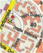


 Sketch map of the hiking trail
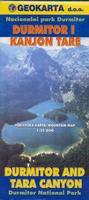
 Sample of the Durmitor hiking map detail
 Image of the entire Durmitor hiking map
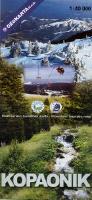
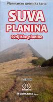
 Image of the entire Suva Planina hiking map.
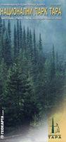
 Sample of the Tara hiking map detail
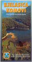
 Sample detail from the Serbia hiking maps
 Index map.
 Sample image #1.
 Sample image #2.
 Sample of the Belgrad map.