Mozambique Road Atlas. 1:430,000. Map Studio, 2009. The Mozambique Road Atlas covers all corners of this largely untouched jewel of Southern Africa. Overview maps include all National Parks & Reserves and Tourist Regions while a considerable collection of street plans cover the capital, Maputo and major towns such as Beira, Pemba, Tete, Inhambane, Vilankulo, Quelimane, Nampula, Cuamba, and Ibo.
This atlas also features introductory sections on the general geography, history, culture and language of Mozambique. It includes over 100 pages of detailed seamless mapping at a scale of 1:430,000 as well as an alphabetical index and list of useful contact numbers for accommodation establishments and tourist attractions throughout the country. The maps in this atlas also feature GPS co-ordinates for all major road junctions.
65-9088
Atlas
$25.95
Waterproof! Mozambique and Malawi Travel Map. 1:1,000,000. Track4Africa, 2011. The roads, tracks, places of interest as well as the distance data and travel time estimates on the map reflect the collective travel experience of the Tracks4Africa community of travellers over the past 10 years, with every single road being GPS recorded and verified by this community. ISBN 9780986987601.
Travel times and distances included on the map
Comprehensive set of roads and tracks in nature reserves
Detailed information on camp sites and attractions
Border crossings indicated with opening and closing times
Visit www.tracks4africa.co.za for detail on places of interest
Complete coverage of Lake Malawi
Overland routes between Mozambique and Tanzania indicated with new Unity Bridge crossing
Each town is shown with up to date tourist services information
Printed on tear and water resistant PolyArt paper suitable for outdoor use
Waterproof! Mozambique and Malawi Travel Map. 1:1,200,000. Reise Know-How. This map, which covers Mozambique and Malawi, combines topographic mapping with good road and tourist information. Elevation is shown via contours, spot heights and altitude tinting. The map shows good road detail and has a 1° latitude/longitude grid for use with a GPS. It includes an index of place names and inset street plans of Maputo and Lilongwe. The legend is bilingual English/German. Map size is 70 x 100 cm, printed on waterproof and tear-resistant Polyart (tm).
65-90904
1 sheet, folded.
$15.99
Mozambique Road Map. Map Studio.
City center inset maps - Maputo, Beira, Nampula, Vilankulo, Inhambane, Quelimane
Detailed area maps - Quirimba archipelago, Mozambique Island, Bazaruto region & island, Inhambane, Inhaca Island, Maputo Bay, Zambezi River & Delta, Gorongosa National Park.
Attractions - what to do and see with contact details.
Information boxes on activities and climate.
History - people and culture.
65-90905
1 sheet, folded.
$16.99
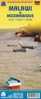
New edition Mozambique and Malawi Travel Map. 1:900,000. ITMB, 5th ed., Sept. 2009. Malawi is a lovely, scenic, and friendly country, doing its best to survive in the harsh African reality. This updated map adds the detailed map of Mozambique to the reverse side. ISBN 9781553413080.
Baja California map sample
64-9990
1 sheet, folded
$12.95
Mozambique Travel Map. 1:2,000,000. Freytag & Berndt. A shaded relief road map, with intermediate distances marked between major road junctions. Colored to show vegetation coverage. Multilingual legend.
Mozamibique 1:200,000 Topographic Maps. Soviet military. These maps offer complete coverage of Mozamibique. Also available as digital maps. In cyrillic.
 Sample detail of the Mozambique and Malawi travel map
 Mozambique Maps

 Waterproof!
 Waterproof!


 New edition
 Baja California map sample
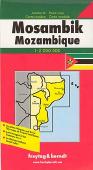

 Sample from the Maputo map.
 Sample from the Entebbe map in the same series.
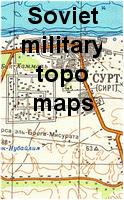
 Mozambique Flags