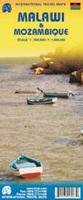
Waterproof! Mozambique and Malawi Travel Map. 1:1,000,000. Track4Africa. The roads, tracks, places of interest as well as the distance data and travel time estimates on the map reflect the collective travel experience of the Tracks4Africa community of travellers over the past 10 years, with every single road being GPS recorded and verified by this community. ISBN 9780986987601.
Travel times and distances included on the map
Comprehensive set of roads and tracks in nature reserves
Detailed information on camp sites and attractions
Border crossings indicated with opening and closing times
Visit www.tracks4africa.co.za for detail on places of interest
Complete coverage of Lake Malawi
Overland routes between Mozambique and Tanzania indicated with new Unity Bridge crossing
Each town is shown with up to date tourist services information
Printed on tear and water resistant PolyArt paper suitable for outdoor use
Malawi City Street Maps. Malawi Survey Dept. These are detailed street maps of the three main cities in Malawi. In English.
$19.95
64-9992BL
Blantyre. 1:16,000. 1985.
$19.95
64-9992M
Mzuzu. 1:10,000. 1989.
$19.95
64-9992Z
Zomba. 1:10,000. 1990.
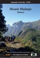
Mount Mulanje Hiking Map. 1:50,000. EWP, 2017.
Detailed, full-colour topographical map of Mount Mulanje, Malawi. The reverse side has useful information on walking routes, accommodation, history, flora and fauna, weather, geology, and photos of area. The map has 25m contours.
$19.99
64-9975
1 sheet, folded.
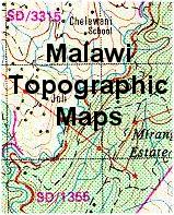
Malawi Topographic Maps
Malawi 1:50,000 Topographic Quadrangle Maps. 1:50,000. Department of Surveys. 1980-. This series will eventually replace the older OS series. Only 11 sheets have been printed (those marked in yellow).
For ordering individual sheets, please look at the index to figure out which sheet(s) you need and then order them
using the "Each, specify area" order button below. On the order form, specify the sheet number in the "Comments" section.
$34.95
64-9952
Per sheet
Malawi 1:50,000 Imperial Series Topographic Quadrangle Maps. 1:50,000. 1950-1971. DOS (425). This series offers complete coverage of Malawi. It will eventually be replaced by the metric series listed above. Those quads marked in yellow are in stock.
For ordering individual sheets, please look at the index to figure out which sheet(s) you need and then order them
using the "Each, specify area" order button below. On the order form, specify the sheet number in the "Comments" section.
$18.95
64-9953
Each
Malawi 1:250,000 Topographic Quadrangle Maps. 1:250,000. Department of Surveys. 1991-94. Ten sheets offer complete coverage. Difficult to obtain and often out of stock.
$34.95
64-9950-01
Karonga. 1992.
$34.95
64-9950-02
Nyika Plateau. 1991.
$34.95
64-9950-03
Mzuzu. 1991.
$34.95
64-9950-04
Mzimba. 1991.
$34.95
64-9950-05
Kasungu. 1991.
$34.95
64-9950-06
Lilongwe. 1991.
$34.95
64-9950-07
Monkey Bay. 1991.
$34.95
64-9950-08
Liwonde. 1991.
$34.95
64-9950-09
Blantyre. 1994.
$34.95
64-9950-10
Nsanje. 1991.
$300.00
64-9951
Set of 10 maps, flat.
Malawi 1:200,000 Topographic Quadrangle Map Set. 1:200,000. Soviet government. High quality topographic maps with good detail. This set gives complete coverage of Malawi in 30 sheets. In Russian.
$360.00
65-99515
Set of 30 sheets, rolled
Malawi Geologic Maps
Sale price while supplies last (no rainchecks). Malawi Geologic Quadrangle Maps. 1:100,000. Geological Survey. 1958-1975. These maps are accompanied by a short descriptive text. There are 40 sheets in 31 bulletins for total coverage.
$10.00
64-9955
Each bulletin + map
Sale price, while supplies last (no rainchecks). Malawi Geologic Quadrangle Maps. 1:250,000. DOS (Geol. 1175) & MGS. 1970-1992.
 Waterproof!
 Sample detail of the Mozambique and Malawi travel map
 Sample detail #1 from the Malawi/Mozambique map
 Sample detail #2 from the Malawi/Mozambique map