Waterproof! Madagascar Travel Map. Reise Know-How. Detailed topographic and road map of Madagascar, printed on waterproof, tear-resistant synthetic paper. In German with English legend.
64-98904
1 sheet, folded
$15.99
Madagascar Road Map. 1:1,000,000. Freytag + Berndt. Includes an inset city map of Antananarivo. Indexed. Map size is 38 x 49 inches unfolded.
64-98908
1 sheet, folded.
$15.99
Madagascar Road Map. 1:800,000. Freytag + Berndt. Includes an inset city map of Antananarivo. Indexed. Map size is 94 x 125 cm. This map has now been discontinued and replaced by the 1:1,000,000 scale map above.
Sample of the map detail.
64-98906
1 sheet, folded.
$14.99
Madagascar Physical Map. FTM. Generalized physical/shaded relief map. In French.
Madagascar Tourist Map. 1:1,250,000. France IGN, 2010, 1st edition. This very attractive map, with cartography by Mairs-Dumont/Falk Verlag, is a shaded relief map of Madagascar. The map shows shaded relief with gradational elevation color tinting, detailed road network (4 levels of road and 2 levels of tracks, plus footpaths) in subdued colors and line width, tourist sites and services denoted by small symbols. Multilingual legend including English. Size is 51 x 38".
Sample detail of the Madagascar Tourist Map.
64-98905
1 sheet, folded.
$16.99
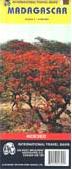
Madagascar Travel Map. ITMB. 1:1,640,000. Relief is shown by altitude tinting, and swamp and salt pan areas are distinguished. Road detail includes some tracks, and railways are also shown. There is a 2° latitude/longitude grid. National parks and administrative district boundaries are included and symbols such things as antiquities, places of interest, landmarks, ports, airports, tourist facilities, and gas stations. The map is indexed and also annotated with geographical and historical notes.
The Comoros islands are included on the map.
Good quality full-color topographic maps. Extensive descriptive text on the reverse side of the paper originals (not included with the digital maps).
Language
In cyrillic (Russian).
64-9852
Set of 106 original paper sheets
$1272.00
64-98521
Set of 106 non-georeferenced raster scans
$2650.00
64-98522
Set of 106 georeferenced raster scans
$5300.00
Madagascar Topographic Map (Carte de Madagasikara). 1:500,000. FTM. There are 8 of 12 sheets available at this time. In French. These maps are often out of stock with an irregular restocking time.
64-9851-01
Comores map. Sheet 1. 1970, reprinted 1998. Out of stock.
$19.95
64-9851-02
Antsiranana map. Sheet 2. 1990.
$19.95
64-9851-03
Mahajanca map. Sheet 3. 1985.
$19.95
64-9851-04
Antalaha map. Sheet 4. 1979.
$19.95
64-9851-05
Maintirano map. Sheet 5. 1990.
$19.95
64-9851-06
Toamasina map. Sheet 6. 1990.
$19.95
64-9851-07
Morondava map. Sheet 7. 1990.
$19.95
64-9851-08
Antananarivo map. Sheet 8. 1990.
$19.95
64-9851-09
Toliara map. Sheet 9. Out of stock.
$19.95
64-9851-10
Fianarantsoa map. Sheet 10. 1990. Out of stock.
$19.95
64-9851-11
Ampanihy map. Sheet 11. 1990.
$19.95
64-9851-12
Tolanaro map. Sheet 12. 1990. Out of stock.
$19.95
Antananarivo 1:10,000 Topographic Map Set. 1:10,000. FTM Madagascar, 1999. This set offers partial coverage of the capital city of Antananarivo. There are 24 sheets in the P47 block currently available, including
P47-A2, A4, B1, B2, B3, B4, C1, C2, C3, C4, F2, F4, G1, G2, G3, G4, H1, H2, H3, H4, I1, I3, M1, M2. Available as a set only. Color plots, plotted by the FTM Madagascar.
Ssmple detail from the Antananarivo topo map
 Waterproof!


 Sample of the map detail.
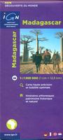
 Sample detail of the Madagascar Tourist Map.

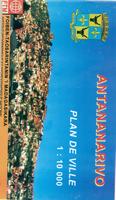
 Ssmple detail from the Antananarivo city map
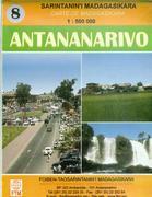


 Ssmple detail from the Antananarivo topo map
 Madagascar Flags