Travel Map of Haiti and the Dominican Republic. 1:400,000/1:350,000. ITMB, Canada.
This map, printed on waterproof and tear-resistant synthetic "paper", covers Haiti at 1:350,000 on one side and the Dominican Republic at 1:400,000 on the other side.
Sample of the Haiti map detail. This sample covers the same area as the sample for 66-33796 below.
66-33720
1 sheet, folded
$12.95
Haiti City Topographic Maps. 1:10,000 or 1:12,500. NGA (NIMA).
Detailed topographic maps of cities with street-level detail. Index includes buildings, points of military interest, streets, and more. With a 1' lat-long grid. Contours typically 10 feet. In English.
NOTE: These maps are not tourist street maps - they are topographic maps and all 1980's-90's era publications. We have been unable to obtain any tourist street maps of Haitian cities.
Sample detail from the Gonaives map. Sample detail from the Entebbe map in the same series. Thumbnail image of the Gonaives map
We stock the 1:50,000 and 1:250,000 and 1:500,000 topographic maps for Haiti and for Dominican Republic; please see the various links below.
In stock!
67-1055-J26C
Sheet J26C - Western Haiti and Jamaica.
$34
67-1055-J27D
Sheet J27D - Eastern Haiti, including Port-au-Prince.
$34
Haiti & Dominican Republic 1;250,000 Topographic Maps. 1:250,000. US DMA JOGs. This eight-sheet set offers complete coverage of Hispaneola (Haiti & Dominican Republic).
Index map for Hispaneola.
67-10581-NE1804
Gonaives (Cap Haitien) NE-18-04.
$24.00
67-10581-NE1807
Les Cayes - NE-18-07.
$24.00
67-10581-NE1808
Port au Prince - NE-18-08.
$24.00
67-10581-NE1901
Santiago - NE-19-01.
$24.00
67-10581-NE1902
San Francisco de Macoris - NE-19-02.
$24.00
67-10581-NE1905
NE-19-05.
$24.00
67-10581-NE1906
Santo Domingo - NE-19-06.
$24.00
67-10581-NE1907
La Romana - NE-19-07.
$24.00
Haiti & Dominican Republic Topographic Map Series - 1:50,000.
 Haiti Maps
 Sample of the Haiti map detail.
 Sample detail from the Gonaives map.
 Sample detail from the Entebbe map in the same series.
 Thumbnail image of the Gonaives map
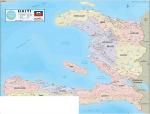
 Image of the Haiti wall map
 Detailed sample of the Haiti wall map
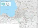
 Image of the Port-au-Prince wall map.
 Detailed sample of the Port-au-Prince wall map
 In stock!
 Index map for Hispaneola.
 Haiti Flags