|
|

Greenland Hiking Maps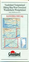
Greenland Hiking Maps. 1:100,000 or 1:75,000. Greenland Tourism (with Harvey Maps & Compukort). Detailed topographic hiking maps covering the most popular parts of the coastal regions of Greenland. 25 meter contours.  Sample image Sample image
 Sample detail from the Nuuk 1:20,000 hiking map Sample detail from the Nuuk 1:20,000 hiking map
 Index map Index map
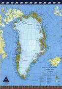
Greenland Topographic Quadrangle Maps. 1:250,000. Kort & Matrikelstyrelsen. We have limited stock left of this series.  Index map for northern Greenland Index map for northern Greenland
 Index map for southern Greenland Index map for southern Greenland
Greenland Topographic Quadrangle Maps. 1:1,000,000. Kort & Matrikelstyrelsen. Available sheets cover approximately 75% of the coastal regions.
Greenland Flags Greenland Flags Greenland Flags
|
||||||||||||||||||||||||||||||||||||||||||||||||||||||||||||||||||||||||||||||||||||||||||||||||||||||||||||||||||||||||||||||||||||||||||||||||||||||||||||||||||||||||||||||||||||||||||||||||||||||||||||||||||||||||||||||||||
 Greenland
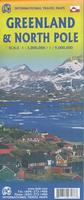


 Thumbnail image of the Greenland map.


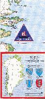
 Index map
 Sample of 6 x 6" section of a sheet.
 Small thumbnail of sheet #1
 Small thumbnail of sheet #4