Tonga is the Pacifics only kingdom and is situated between Fiji and Samoa, north-east of New Zealand. The Friendly Islands archipelago consists of five island groups and 171 islands, most of which are uninhabited. The map contains detailed maps of each major island and includes tourist information and hotels. An inset of the capital, Nuku Alofa, is included.
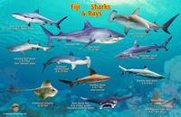
Fiji Sharks & Rays Card. Franko's Map.
Each laminated card is a beautiful identification card with dynamic illustrations. Side One features inshore species. Side Two shows offshore species. This convenient, waterproof reference is made of hard, laminated plastic with a hole for a lanyard. 5.5" x 8.5".
Front side of the Fiji sharks and rays card Reverse side of the Fiji sharks and rays card
 Sample detail from the Fiji map
 Thumbnail image of the Fiji side of the map
 Thumbnail image of the Tonga side of the map
 Front side of the Fiji sharks and rays card
 Reverse side of the Fiji sharks and rays card
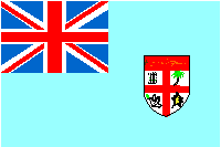
 Fiji Flags