Waterproof! Ecuador Travel Map. 1:700,000. ITMB. Shaded relief physical/road map. Elevation is shown by spot heights and elevation tinting. Different categories of roads (highways, major, tracks, etc.) are shown along with gas stations and distances between major road junctions. Inset maps cover Quito and Guayaquil and its surroundings. Such tourist sites and information as national parks, active volcanoes, thermal baths, ruins, are marked.
4" x 4" sample image
64-50901
1 sheet, folded
$12.95
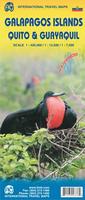
Waterproof Galapagos Travel Map. 1:7,500 - 1:420,000. ITMB. This edition has three changes to note. The first is the road network, basic though it is, has been updated; the second is that most of the sketches that have graced the map for six editions have been replaced by photos; and the third is that the cover photo is one of ITMB's own pictures for the first time. Going to the Galapagos brought to ITMB's attention the importance of 'how' to do so. There are only two places on earth for visitors to leave from in order to land in the Galapagos - Quito and Quayaquil - so we've added large insets of both cities to the map to assist visitors needing to find their way around those cities before and after visiting the sea lions. Printed on waterproof paper.
Sample detail #1 of the Galapagos Travel Map Sample detail #2 of the Galapagos Travel Map
64-5091
1 sheet, folded.
$12.95
Laminated! Ecuador Travel Map. 1:1,000,000. Borch. A laminated travel map with city center insets of Quito, Cuenca, and Guayaquil.
4" x 4" sample image
64-50907
1 sheet, folded
$11.95
(Ecuador) Quito & Northern Ecuador Map. 1:12,500. ITMB. A good tourist map of Quito, noting the locations of tourist sites and services, with a full index. The reverse side has a detailed road map of northern Ecuador and Quito area.
64-5092QB
1 sheet, folded
$10.95
Chimborazo Trekking/Orthophoto Map. 1:20,000. 2009. Arbeitsgemeinshcaft für vergleichende Nochgebirgsforschung (Prof. Dr. E. Jordan, Düsseldorf and Prof. Dr. M. Buchroithner, Dresden). Detailed 1:20,000 topographic map overlain on an orthophoto
Sample of the Chimborazo hiking map detail
64-5081
1 sheet, folded.
$24.99
Chimborazo benchmark paperweight. Geo-Situ. Whether you're a climber, hiker, geography buff, or armchair traveler, you'll love to collect or give these unique bench mark paperweights that celebrate the spirit of exploration, athletic challenge, and personal achievement. Cast in pewter these summit marker paperweights are the same diameter as and in the style of official USGS benchmark markers. Each marker has a soft felt pad on the bottom so these can be used on glass, wood, or any surface. Supplied in a soft fleece drawstring pouch, 3¼" diameter.
Larger image of the Chimborazo paperweight.
64-5097CH
Paperweight.
$59.95
Cotopaxi Climbing Map. 1:40,000 & 1:250,000. Climbing Map, Switzerland, 2009. Topographic climbing map with useful information and illustrations: climbing map at 1:40,000; city map of Quito; general map at 1:250'000; Avenida de los Volcanes; description of climbing routes; vegetation profile; climatic diagram; GPS- information, etc. Multilingual, including English. ISBN 978-3-9523294-2-9.
Sample #1 of the topographic map. Sample #2 of the trekking map. Sample #3 of the Mendoza city map.
64-5078
1 sheet, folded.
$28.99
Cotopaxi benchmark paperweight. Geo-Situ. Whether you're a climber, hiker, geography buff, or armchair traveler, you'll love to collect or give these unique bench mark paperweights that celebrate the spirit of exploration, athletic challenge, and personal achievement. Cast in pewter these summit marker paperweights are the same diameter as and in the style of official USGS benchmark markers. Each marker has a soft felt pad on the bottom so these can be used on glass, wood, or any surface. Supplied in a soft fleece drawstring pouch, 3¼" diameter.
Larger image of the Cotopaxi paperweight.
64-5097CO
Paperweight.
$59.95
Waterproof! Galapagos Travel Map. 1:500,000. ITMB. An excellent map that shows good physical features of this island group famous from Darwin's travels.
64-5091
1 sheet, folded
$12.95
Recommended Galapagos Islands Explorer Maps. 1:1,100,000 & 1:4,000,000. Ocean Explorer Maps, UK. This excellent series of maps are ideal for students and the classroom. While not really usable as a road map, the extensive historical, biological, and geographic information makes these maps extremely useful.
Generalized shaded relief maps, often with roads.
Illustrated biographies of the major explorers of the region.
Trekking in Ecuador. By Daisy & Robert Kunstaetter. The Mountaineers Books. The definitive travel guide to exploring the unique diversity and splendor of Ecuador.
Ecuador is one of the leading Latin American destinations
Details 30 amazing trekking adventures for all levels of hikers
Includes the history of Ecuador, its people, geography, where to stay and more
64-5095TR
Guide.
$18.95
Ecuador: A Climbing Guide. By Yossi Brain. The Mountaineers Books. A comprehensive climbing guide to all the major peaks in Ecuador.
Introduces climbers to twenty of the country's major peaks, including the volcanic "Big Ten."
Illustrated with 25 photographs, 17 maps, and 24 topos.
Includes advice on preparations, local transportation, supplies, climbing resources, and health tips.
Features one of the most enticing climbing destinations in the world.
64-5095CL
Guide.
$16.95
Topographic Maps
Ecuador Topographic Quadrangle Maps. IGM. In Spanish. We stock the 1:50,000 (approximately 225 of 588 sheets available); the 1:100,000; and 1:250,000 maps.
New Atlas of Ecuador (Nuevo Atlas del Ecuador). Ediguias C. Ltda. 1999. This is a decent high-school-level summary atlas for Ecuador. 70 pages of maps, typically one per page, grouped into sections of historical maps, physical maps, administrative maps, population maps, economic maps, and world maps. In Spanish.
64-5049
Atlas
$29.95
Ecuador Political Map (Mapa Político). 1:1,000,000. IGM. 2000. A hydrography base map with political divisions overprinted, plus main roads, towns, etc. In Spanish.
64-50485
1 sheet, rolled
$16.95
Ecuador Physical Map (Mapa Físico). 1:500,000. IGM. Six sheets, in color. In Spanish. The map contains contour lines, paved roads, major unpaved roads, airfields, and much more.
64-50488
6 sheets, rolled
$59.95
Ecuador Physical Map (Mapa Físico). 1:1,000,000. IGM. One sheet, in color. In Spanish. This is an excellent overall map of Ecuador. The map contains contour lines, paved roads, major unpaved roads, airfields, and much more. We recommend this map as a larger planning map for treks, or for driving.
64-50487
1 sheet, rolled
$24.95
Ecuador Geological and Thematic Maps
Ecuador Geologic Map (Mapa Geológico de la Republica del Ecuador). 1:1,000,000. 1993. CODIGEM & BGS. In Spanish.
64-5000
1 sheet, folded
$34.95
Ecuador Hydrogeologic Map (Mapa Hidrogeológico). 1:1,000,000. 1983. DGGM. Complete with 15-page text. In Spanish.
64-5030
Set, folded
$19.95
Ecuador Metallogenic Map (Mapa Metalogénico de Ecuador). 1:1,000,000. 1980. MRNE, Ecuador. Companion map to #64-5000 above. 121 x 93 cm. In Spanish.
64-5040
1 sheet, folded
$19.95
Ecuador Mineral Index Map (Mapa Indice Mineralógico). 1:1,000,000. 1962. MRNE. The map shows geology with mineral/economic deposit occurrences. Two sheets; in Spanish.
64-5041
2 sheets, rolled
$27.95
(Ecuador) Geologic Map of Northeast Quito. 1:25,000. MRNE. These maps will eventually cover the entire Quito area. These first sheets cover the volcanic area to the northeast. There are three maps per quadrangle; geology, geomorphic zones, and slope. The four quadrangles covered are Guayllabamba, San Antonio de Pichincha, Chaupicruz, and El Quinche. Twelve sheets; in Spanish.
64-50543-01
Chaupicruz. 3 sheets, rolled
$19.95
64-50543-02
Guallabamba. 3 sheets, rolled
$19.95
64-50543-03
El Quinche. 3 sheets, rolled
$19.95
64-50543-04
San Antonio. 3 sheets, rolled
$19.95
Ecuador Geologic Quadrangle Maps. 1:100,000. MRNE. Most maps are in color; a few are black and white. Available quadrangles cover about 20% of the country. In Spanish.
64-5056
Per sheet, specify area
$15.95
64-5057
Set of 78 sheets
$858
Ecuador State Geologic Maps (Mapa Geológica del Estado de...). 1:250,000. MRNE. In Spanish.
64-5058AR
Aragua. 1978.
$19.95
64-5058DN
Del Napo. 1984.
$19.95
64-5058MO
Morona. 1980.
$19.95
64-5058PA
Pastaza. 1984.
$19.95
64-5058ZA
Zamora. 1980.
$19.95
(Ecuador) Industrial Rocks of the Quito Area. 1:100,000. MRNE. One sheet, in color. In Spanish.
64-5060-QU
1 sheet, rolled
$9.95
(Ecuador) Industrial Rocks of the Sangolqui Area. 1:100,000. MRNE. One sheet, in color. In Spanish.
64-5060-SA
1 sheet, rolled
$9.95
(Ecuador) Geologic Map of Guagua Pichincha Volcano (Mapa Geológico del Volcán Guaua Pichincha). 1:50,000. INEMIN. 1989. Shows the geology of this well-known volcano near Quito. In Spanish.

 Waterproof!
 4" x 4" sample image
 Waterproof
 Sample detail #1 of the Galapagos Travel Map
 Sample detail #2 of the Galapagos Travel Map
 Laminated!
 4" x 4" sample image

 Sample of the Chimborazo hiking map detail
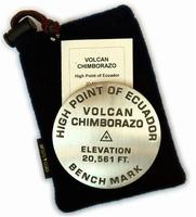
 Larger image of the Chimborazo paperweight.
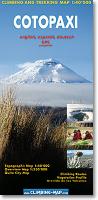
 Sample #1 of the topographic map.
 Sample #2 of the trekking map.
 Sample #3 of the Mendoza city map.
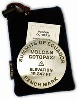
 Larger image of the Cotopaxi paperweight.
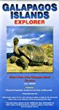 Recommended
 Thumbnail of the front of the map
 Thumbnail of the reverse of the map