We stock the largest selection of maps of the Caribbean and the individual islands. Listed below are some of the regional maps that we stock. For more detailed mapping, please see the individual country/island listings.
New atlas Caribbean East & South Travel Atlas. Variable scales. ITMB, 2014.
Traditionally, these were called the Leeward and Windward Islands, but the term Eastern Caribbean is more commonly used by cruise ships. The list of islands included in this atlas is lengthy and includes Barbados, Grenada,Guadeloupe/Martinique, St. Kitts/Nevis, St. Lucia, St. Vincent, both sets of Virgin Islands, Trinidad/Tobago and the Dutch colonies of Aruba, Bonaire, and Curacao. It gives complete coverage of the Caribbean islands when combined with the Western Caribbean atlas released last year. 160 pages, 18 town plans. ISBN 9781553415220.
Shows areas covered by the atlas
66-3349E
Eastern and Southern Caribbean Travel Atlas. New title!
$16.95
Caribbean Islands West Half Travel Atlas. Variable scales. ITMB.
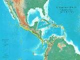
The Caribbean is a particularly difficult part of the world to map effectively. It is a combination of larger islands in the west and a string of small islands in the east. Some can be shown as separate maps, but others are too small to be mapped adequately as folded paper maps. This atlas covers the Bahamas and the Turks and Caicos Islands in the north with Cuba, the Cayman Islands, Jamaica, the Dominican Republic, and Puerto Rico in scales ranging from 1:18,000 for Puerto Rico to 1:600,000 for Cuba. The atlas size is 8" x 5" (21 x 13.5cm). Inset maps of Freeport, Nassau, Havana, Varadero, Georgetown, Kingston, Port Au Prince, Santo Domingo, and San Juan are included. The level of detail is identical with ITM's folded maps; this is for those wishing the convenience of information in a convenient book format, with no loss of detail.
Sample detail of the Western Caribbean Islands Travel Atlas
66-3349W
Atlas.
$16.95
Caribbean Travel Maps
Recommended! Caribbean Travel Map. 1:4,000,000. Michal Kasprowski. A very nice map of the entire Caribbean region, with inset maps of each of the islands in the margins.
Covers the Caribbean region in detail, including the Bahamas, Virgin Islands and Central America, and features enlarged insets of most of the islands.
Indicates main and secondary roads, national and international airports, lighthouses, reefs, volcanoes, national parks, ports, water depths, and other helpful information and points of interest.
Useful both for traveling or framing as a wall display, this map is a practical and decorative reference tool.
Size is 98 x 67 cm (38 1/2 x 26 3/8 in.).
66-33985
1 sheet, folded
$16.99
Caribbean Islands Explorer Map. Ocean Explorer Maps, UK. This excellent map is ideal for students and the classroom. While not really usable as a road map, the extensive historical, biological, and geographic information makes the map extremely useful.
Generalized shaded relief maps, often with roads.
Illustrated biographies of the major explorers of the region.
Recommended! The Caribbean Map and Guide. 1:3,500,000. National Map Centre. A very attractive map that uses a shaded relief map as the base and then each country is colored differently. The map includes main roads, cities and towns. The front side has the main map at 1:3,500,000 which covers the entire region. There are inset maps for eight of the islands in the margin. The reverse side has color photographs and a couple of paragraphs of information about the region and 21 of the islands. No ISBN.
Caribbean Region Travel Maps. 1:2,500,000. Nelles Verlag. These maps offer the best coverage of the region. The southern sheet covers the Lesser Antilles with inset maps of the major tourist island. The northern sheet - out of stock indefinitely while the publisher decides to reprint the map or not - covers Bermuda, Bahamas, Cuba, Haiti, Dominican Republic, and Bimini.
Sample detail from the Lesser Antilles map Sketch map showing area covered by the Lesser Antilles map
Waterproof! Caribbean Sea Guide Map. Franko's. Waterproof map showing the islands of the Caribbean. The front has a physical map fo the Caribbean Sea which also shows ocean floor topography. The reverse side has the same map but with a short text block for each island. Small illustrations of the most common fishes are also shown.
Sample detail of the Caribbean Sea Map Front of the Caribbean Sea Map Reverse of the Caribbean Sea Map
Northern Caribbean Travel Map. The Caribbean Northern Islands Guidemap includes sections for Anguilla, Antigua, Barbuda, British Virgin Islands, Guadaloupe, Montserrat, Nevis, Saba, St Maarten, St Barthelemy, St Eustatius, St Kitts, St Martin, and the US Virgin Islands.
$6.95
66-33981S
Southern Caribbean Travel Map. The Caribbean Southern Islands Guidemap includes sections for Barbados, Dominica, Jamaica, Martinique, St Vincent & the Grenadines.
$6.95
Eastern Caribbean Cruise Tour Guide/Map - Leeward and Windward islands. Coastal Cruise Tour Guides. Reaching in a graceful arc from Puerto Rico to South America, the Leeward and Windward islands of the Eastern Caribbean are like an iridescent diadem, each island a unique gem, sun-splashed, set against a cobalt sky, an aquamarine sea. All islands in this most intriguing area of the Caribbean are featured with descriptive text and large-size color maps - Puerto Rico, U.S. and British Virgin Islands, Anguilla, St.Martin/Sint Maarten, St.Barts, Saba, St.Eustatius, Nevis, Barbuda, Antiqua, Montserrat, Guadaloupe, Dominica, Martinique, St.Lucia, Barbados, St.Vincent and the Grenadines, Grenada, Trinidad and Tobago.
Sample detail from the Eastern Caribbean Cruise map.
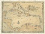
Caribbean Antique-style Wall Map. 33 x 25".
Bordered by the United States, Mexico, Central America, and South America, the Caribbean Sea covers almost a million square miles. Its warm waters reach an average depth of 8,448 feet. The lush, windswept islands of the Caribbean are home to more than twenty-five million people. Its larger islands include Cuba, Haiti, the Dominican Republic, Jamaica, and Puerto Rico.
66-33461
1 sheet, rolled.
$25.00
66-33461D
Deluxe frame
$275.00
Geology Maps
Caribbean Seismicity: 1900-1994. USGS. More than 16,000 earthquakes recorded in the Caribbean region during this century are presented on this wall map (51 x 31").
Epicentral locations of earthquakes of magnitude 4.2 or greater that occurred in 1900-1994 are indeicated on the map, along with population centers with more than
25,000 inhabitants. Base map from Raven Maps.
66-3316
Each, rolled
$14.95
Tectonic Map of the Eastern Greater Antilles. 1:500,000. 1972. USGS (I-732).
 New atlas
 Shows areas covered by the atlas

 Sample detail of the Western Caribbean Islands Travel Atlas
 Recommended!


 Thumbnail of the front of the map
 Thumbnail of the reverse of the map.
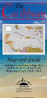 Recommended!

 Sample detail of the Caribbean Travel Map
 Image of the front of the Caribbean Travel Map
 Image of the reverse of the Caribbean Travel Map
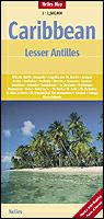
 Sample detail from the Lesser Antilles map
 Sketch map showing area covered by the Lesser Antilles map
 Thumbnail of the front side
 Thumbnail of the reverse side
 A sample of the detail of the map
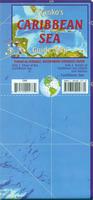 Waterproof!
 Sample detail of the Caribbean Sea Map
 Front of the Caribbean Sea Map
 Reverse of the Caribbean Sea Map
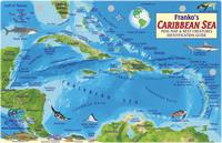 Waterproof!
 Front of the Caribbean Sea Fish Card
 Reverse of the Caribbean Sea Fish Card
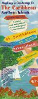 Waterproof!
 Front of the Northern Caribbean Sea Map
 Sample detail #1 of the Northern Caribbean Sea Map
 Sample detail #2 of the Northern Caribbean Sea Map
 Sample detail of the Southern Caribbean Sea Map
 Sample detail from the Eastern Caribbean Cruise map.
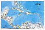
 An image of the full map
 A detail of the map
 A sample of the legend