The maps listed here are overview and general road maps. For more detailed mapping, including topographic maps, please look in the individual country listings, such as Albania, Croatia, etc.
Waterproof The Western Balkans Travel Map. 1:725,000. Reise Know-How. This map combines topographic mapping with road and tourist detail. The road information is clear and elevation is shown using contours, spot heights and altitude shading. The map shows six different types of roads, highlighting scenic routes, places of interest, archaeological sites, monasteries, monuments and viewpoints.
Includes coverage of: Albania, Bosnia & Herzegovina, Kosovo, Macedonia, Montenegro, Serbia, and Slovenia.
Sample detail of the Western Balkans map
66-22673
1 sheet, folded.
$15.99
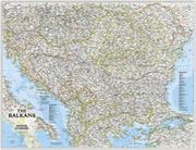
The Balkans Map. 1:1,948,000. National Geographic Society.
The Countries of the Balkans wallmap features thousands of place-names, political boundaries, national parks, and major infrastructure networks such as roads, canals, ferry routes, and railroads. The region's diverse terrain is detailed through shaded relief, coastal bathymetry, and symbols for water features and other landforms. Elevations of major peaks as well as depth soundings are expressed in meters.
The map covers Albania, Austria, Bosnia and Herzegovina, Bulgaria, Croatia, Hungary, Kosovo, Macedonia, Moldova, Montenegro, Romania, Slovenia, as well as the outlying border countries of Greece, Italy, Slovakia, Serbia, Turkey and Ukraine.
Thumbnail view of the map
66-2268
1 sheet, rolled.
$11.99
66-2268L
1 sheet, laminated.
$19.99
Balkans & Southeastern Europe Road Map. 1:2,000,000. Freytag & Berndt. This map covers the Balkans and much of South-Eastern Europe. It extends from Dresden in the north to Crete in the south and from Trieste to Ankara, including all of the Czech and Slovak Republics, Hungary, Romania, Bulgaria and Greece as well as eastern Austria, south-western Ukraine, and western Turkey. Roads, railways, airports and ferry connections are shown, and the topography is indicated by relief shading and some spot heights. Road distances between selected points are shown on the map, and there is a separate index of place names, classified by country. Latitude and Longitude lines are printed over the map at intervals of 1° and 2° respectively.
Index showing map coverage Sample of the map detail
 Waterproof
 Sample detail of the Western Balkans map
 Thumbnail view of the map
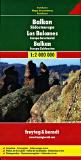
 Index showing map coverage
 Sample of the map detail