Antigua & Barbuda Travel & Topographic Map. 1:30,000 (Antigua) and 1:35,000 (Barbuda). Michal Kasprowski, 2013. The map shows in great detail roads and streets with their names and locates hiking trails, diving sites, parish boundaries, insets of the islands' respective capitals, and several shipwrecks off Barbuda.
The double-sided map, with one island on each side, is 26 3/8" x 38 1/2" when opened. The maps have three levels of roads (footpaths, secondary roads, and main roads) and symbols representing a large number of physical features.
The maps contain the following features:
Extensive topographic detail;
Symbol key, scale, and street index;
Airports, beaches, beacons, caves, cemeteries, churches, diving sites, gas stations, geological formations, hiking trails, hill shading, hospitals, a lighthouse, marinas, moorings, parish boundaries, parking areas, police stations, ports, post offices, reefs, shipwrecks, old sugar windmills, and other points of interest.
Antigua & Barbuda travel map. 1:35,000. ITMB. Clear, simple road map, with a street plan of St. John's and an enlargement of the English Harbour area. Elevation tinting and spot heights indicate the topography of the island. Road network includes unpaved roads and local footpaths are also shown. Coral reefs, beaches, golf courses, selected accommodation, places of interest, etc. are indicated. Latitude and longitude lines are drawn at 5' intervals. Map size is 69 x 99 cm.
Four insets show a street map of St John's, an enlargement of the English Harbour area, a map of Barbuda at approx. 1:300,000, and a small simplified map of the whole of eastern Caribbean.
66-33634
1 sheet, folded
$10.95
Antigua & Barbuda Road Map & Guide. Approx. 1:80,000. Skyviews. 19th ed., 2010/2011. The map is a pocket tourist map, not a topographic or detailed physical map, but it is excellent at what it does. The map has an island map on the front with inset maps of Dickenson Bay and St. John's. The reverse side is loaded with useful tourist information such as bike/car/taxi rental, restaurants, sites, hotels, and much more. Antigua, also known as 'Wadadli' meaning 'our own', is the largest of the Leeward Islands. The circumference is roughly 54 miles and its area is 108 square miles. The island is the most developed of the Leeward Islands and is prosperous due to its upscale tourism industry, offshore banking, gambling and education services. A folded pocket version and a laminated flat version are available; the laminated version is ideal as a souvenir placemat. Size is 20 x 14 inches.
Sample detail from the Antigua road map. Image of the entire Antigua road map.
66-33633
1 sheet, folded.
$6.99
66-33633L
1 sheet, laminated.
$10.99
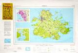
Antigua Topographic Map. 1:50,000. 1980. DOS (406), Britain. This map offers topographic coverage of this Lesser Antilles island with an inset map of St. Johns. 97 x 66 cm.
Sample of the map detail Thumbnail of the entire map
Antigua Antique-style wall map. 23 x 28".
A British colony since 1632, Antigua was granted independence in 1981. Located in the Leeward Islands of the West Indies, it covers 171 square miles with a population of 65,000 people. English is the national language and the form of government is a constitutional monarchy. Tourism and the manufacture of rum are foundations of the island's economy. Antigua's capital city is St. John's.
 Antigua Maps and Antigua Guides
 Sample detail from the Antigua road map

 Sample detail from the Antigua road map.
 Image of the entire Antigua road map.
 Sample of the map detail
 Thumbnail of the entire map
 Sketch map showing sheet layout of the Antigua 1:5,000 map series
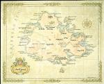

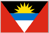
 Antigua Flags