Austria Cycling Maps. Freytag & Berndt, 2007. These are new cycling route strip maps, ideal for carrying on a bike. The maps have an accordian-fold strip map of the route, brief description of the main sites and/or villages in that route section, and useful information such as hotels, telephone numbers, locations of bike repair shops, etc.
Sample of the Danube map detail
$12.99
64-1481-01
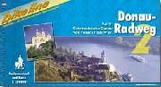
Donauradweg - Danube Bike Trail.
$12.99
64-1481-02
Innradweg - Inn Bike Trail.
$12.99
64-1481-03
Mozartradweg - Mozart Bike Trail.
$11.99
64-1481-04
Salzkammergut Radweg - Salzkammergut Bike Trail.
$12.99
64-1481-05
Tauernradweg - Tauern Bike Trail.
$11.99
64-1481-06
Drauradweg - Drava Bike Trail.
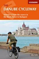
The Danube Cycle Way Guide. Cicerone, UK. The first in a two-volume set, this guidebook describes cycling the first 1271km of the Danube river from its source in the Black Forest to Budapest, passing through Germany, Austria, Slovakia and Hungary. Suitable for all levels of cyclist, the route visits the great cities of Vienna and Bratislava before arriving in the Hungarian capital.
NOTE: Volume 2, covering from Budapest to the Black Sea will be coming out later this year.
Danube Bike Trail Vol. 1 - Donaueschingen to Passau. 1:50,000 scale maps + 17 city maps, 152 pages.
$19.99
66-2279-DA2
Danube Bike Trail vol. 2 - Passau to Vienna 1:50,000 scale maps + city maps, 160 pages. The most popular section of the Danube Trail. In English.
$19.99
66-2279-DA3
Danube Bike Trail Vol. 3 - Vienna to Budapest. 1:75,000 scale maps + 5 city maps, 132 pages.
$19.99
66-2279-DA4
Danube Bike Trail Vol. 4 - Budapest to the Sea. 1:75,000 scale maps + 5 city maps, 132 pages. Covers from Budapest, through Belgrad, and Bucharest to the Sea at Tulcea.
Austria Cycling Atlas. 1:50,000 - 1:200,000. Freytag & Berndt. A guide describing 160 cycling tours throughout the country, each manageable in a few hours. Descriptions, in German only are accompanied by map extracts at 1:50,000 or 1:200,000 (or street plans where appropriate) on which the routes are highlighted. In German only.
Sample of the route descriptions Sample of the maps
$31.95
64-1471
Atlas.
Austria Cycling Atlas. Bikeline/Esterbauer. This atlas presents 90 cycle tours in Austria, covering in total about 3300 km. Routes are between 15 & 50 km in length and suitable for day or weekend trips.
As with the other Bikeline cycling publications, each tour description is accompanied by a clear and concise map showing the route and surroundings. The cartography at 1:50,000 and 1:100,000 distinguishes different types of cycle path eg. those with or without motor traffic, variations in quality of surface. Other details include spot heights, steep or light gradient indicators, intermediate distances, railways, footpaths, tunnels & bridges.
In addition to showing landmarks and landscape features eg. churches, castles, towers, monuments, historic sites, viewpoints, nature reserves, forests, vineyards etc, the mapping includes plenty of symbols to indicate an extensive range of features and facilities for tourists. These include campsites, guesthouses, tourist information offices, shopping facilities, ferries, car parks, bike workshops & bike stands. Where appropriate, small street plans for towns are also provided.
Each tour description includes useful contact details for local facilities and places to visit. Like the majority of titles by this publisher, the text is in German only, although the extensive map legend includes English translations.
The volume is in ring-binder format so that the A4 size pages for chosen routes can be removed. 219 pages.
Index showing locations of described rides Sample of the route descriptions Sample #1 of the maps Sample #2 of the maps
Bodensee Bike Trail (Rund um den Bodensee, Überlinger See und Untersee). In German.
$26.95
64-1483-BUR
Burgenland Cycling Atlas (Burgenland Radatlas). In German.
$26.95
64-1483-DRA
Drau Bike Trail (Drau Radweg). In German.
$21.95
64-1483-ENN
Enns Bike Trail (Enns Radweg). In German.
$26.95
64-1483-ENG
Engadine - Val Müstair, Nauders - Reschenpass, Vinschgau. In German.
$24.95
64-8296AD
Etsch Bike Trail (Etsch Radweg). A 325-km route along the river Adige/Etsch from its source to Merano, Bolzano, Trento and Verona. In German.
$24.95
64-1483-IN1
Inn Bike Trail: Vol. 1, Innsbruck to St. Moritz (Inn Radweg 1). Covers the Inn River trail from Innsbruck south to St. Moritz in Switzerland. In German.
$19.99
64-1483-IN2
Inn Bike Trail: Vol. 2, Innsbruck to Passau (Inn Radweg 2). Covers the Inn River Trai from Innsbruck north to Passau in Germany. In German.
$33.99
64-1483-KAM
Kamp-Thaya-March Bike Trail. A popular bike route in the area just north of Vienna, along the Kamp, Thaya, and March rivers. In German.
$27.95
64-1483-KAR
Kärnten Cycling Atlas (Radatlas Kärnten). Centered on the Drau River and Klagenfurt. In German.
$25.95
64-1483-MUR
Mur Bike Trail (Mur Radweg). Along the Mur River from St. Michael to Bad Radkersburg. In German.
$26.95
64-1483-MO1
Moststrasse Cycling Atlas (Radatlas Moststrasse). Covers the Danube River from Enns to Ybbs. In German.
$25.95
64-1483-MO2
Mostviertel Cycling Atlas (Radatlas Mostviertel). Covers the Danube River west of St. Pölten and southwards. In German.
$24.95
64-1483-MOZ
Mozart Bike Trail (Mozart Radweg). This is a beautiful trail from Salzburg along the Inn River, past the Chiemsee and several other lakes back to Salzburg. In German.
$20.95
64-1483-NEU
Neusiedler See Bike Trail (Neusiedler See-Radweg). A nice route around the Neusiedler See (lake). In German.
$14.99
64-1483-RFW
Long Distance Cycling Ways in Austria (RadFernWege Österreich). In German.
$17.95
66-2279-RET
Retzer Land - Zanimer Land. 1:50,000. In German.
$23.99
64-1483-SAL
Salzkammergut Cycling Atlas (Radatlas Salzkammergut). 1:75,000. In German.
$27.95
64-1483-TAU
Tauern Cycling Trail (Tauern Radweg). 1:50,000. Covers from the Danube River south along the Inn and Salzach Rivers through Salzburg to Krimml. In German.
$24.99
64-8296VI
Via Claudi Augusta. 1:75,000. From the Donau to the Adriatic. In German.
$25.95
66-2279-VOR
Vorarlberg Cycling Atlas (Radatlas Vorarlberg). 1:60,000. A beautiful ride along the Rhein River from Lindau to Chur in Switzerland. In German.
$24.95
64-1483-WAL
Waldviertel Cycling Atlas (Radatlas Waldviertel). 1:75,000. Covers from the Danube River between Ybbs and Krems, northward to Raabs and the Thaya River. In German.
$24.95
64-1483-WEI
Weinviertel Cycling Atlas (Radatlas Weinviertel). 1:75,000. Covers the area northwards from the Danube River and Salzburg. In German.
$26.95
64-1483-WIER
Vienna Region Cycling Atlas (Radatlas Rund um Wien). 1:50,000 and 1:75,000. Cycling atlas for the wonderful cycling region around Vienna. In German.
$26.95
64-1483-WIEN
Vienna Cycling Atlas (Radatlas Wien). 1:15,000 and 1:50,000. Cycling atlas for the city of Vienna. In German.
$27.95
64-1483-WIRA
Vienna Forest Region Cycling Atlas (Radatlas Wienerwald). Cycling atlas for the forest area south and southwest of Vienna. In German.

 Sample of the Danube map detail
 Now in English!
 Index for Danube part #1 route.
 Index for Danube part #2 route.
 Index for Danube part #3 route.
 Index for Danube part #4 route.
 Map sample from vol. #1.
 Map sample from vol. #2.
 Map sample from vol. #3.
 Map sample from vol. #4.
 Sample of the route descriptions
 Sample of the maps
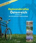
 Index showing locations of described rides
 Sample of the route descriptions
 Sample #1 of the maps
 Sample #2 of the maps
 Index showing coverage of the guides listed below.
 Sample of a road map page
 Sample of a city map page
 Sample of one of the description pages


