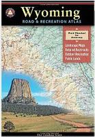
Wyoming Road and Recreation Atlas. 1:250,000. Benchmark Maps, 2008. Wyoming is the heart of the American West. Experience the wild spirit of Wyoming with Benchmark's Wyoming Road & Recreation Atlas. Benchmark's field-checked Landscape Maps clearly depict the terrain, and pinpoint the many backroads that crisscross the state. The Recreation Guide details the many outstanding recreation destinations and opportunities within.
Sample detail from the Wyoming recreation atlas.
$26.95
63-02482
Atlas
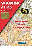
Wyoming Topographic Atlas and Gazetteer. DeLorme. An excellent topographic road atlas. A must for hiking or backroad enthusiasts.
$24.95
63-0248
Atlas
Wyoming Road Maps - Paper maps
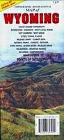
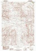
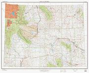
Wyoming Recreation Map. 1:792,000. GTR Mapping. Detailed travel map - Interstates, exit numbers, highways, most local maintained roads. Topographic contours each 1,000 feet and color shaded each 2,000 feet above 6,000 feet. Features include national forests, wilderness, campgrounds, parks, state game & fish areas, ski areas, mining districts, points of interest, and more. Size is 24 x 37".
Sample detail from the Wyoming recreation map.
$5.95
63-0291
1 sheet, folded.
Wyoming Road and Recreation Map. Benchmark Maps. A new detailed recreation and road map of Wyoming.
High-quality folded map designed specifically for outdoor adventure
A richly-detailed state road map with extensive backcountry information
Public Lands and Mule Deer units shown
Hundreds of campgrounds, RV parks, points of interest, and recreation sites
Wyoming Road Map. Rand McNally. The map includes inset maps of Billings, MT; Butte, MT; Casper, WY; Cheyenne, WY; Great Falls, MT; Helena, MT; Missoula, MT; Waterton-Glacier International Peace Park, and Yellowstone/Grand Teton National Parks.
$7.99
62-7890
1 sheet, folded.
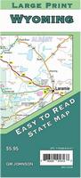
Wyoming Road Map - Large print. 1:700,000. GM Johnson.
This double-sided map has slightly larger than normal text on it, making it easier to read. There Casper, Cheyenne, Cody, Evanston, Gillete, Grand Teton National Park, Green River, Jackson, Laramie, Rawlins, Riverton, Rock Springs, Sheridan, Yellowstone National Park
Sample detail of the Wyoming Road Map Front of the Wyoming Road Map Reverse side of the Wyoming Road Map
$5.95
63-02901
1 sheet, folded.
Wyoming Road Maps - Laminated Maps
Laminated Wyoming & Montana Road Map - Laminated Map. Rand McNally. The durable and convenient Montana and Wyoming EasyToFold state map will take all the wear and tear your journey can dish out. The heavy-duty laminated design allows you to mark your route, make notes, then wipe the surface clean for further use. This is a must-have for navigation whether you're a state resident or just passing through. Map size is 18 x 17" ufolded.
$7.95
62-78902
1 sheet, folded.
Wyoming City Maps
Casper, Cheyenne, and Laramie City Map. Mapsco.
This full-color street map of Casper, Cheyenne, and Laramie includes: Evansville, Mills, and West Laramie; and features: Airports, Colleges and Universities, Golf Courses, Hospitals, Parks and Rec Areas, Places of Interest, Schools, and ZIP Codes.
Sample from the Casper street map.
Wyoming City, County, and State Business Wall Maps
Wyoming City Wall Maps.
When it comes to general planning, defining delivery areas, planning direct marketing and delivering products, our city wall maps are perfect to get the detailed information you need.
These maps offer clear mapping by showing all major streets and roads, but leaving out the smaller streets.
If you want a clear map for easy planning, then these are the maps for you; if you want a map showing every little back alley, these are not for you.
We offer state and county wall maps for all of the USA. The maps come in sizes from 24 x 36 to 108 x 144 inches. They are available in variety of mounting and framing options. The maps are ideal for business applications, sales territory, delivery planning, direct mail targeting and hundreds of other applications.
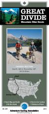
Wyoming Bicycling Maps. Wyoming has two long-distance trail that traverses the state - the Great Divide Cycling Trail and the TransAmerica Cycling Trail.
Waterproof! Jackson Hole Trail Map. 1:95,040 and 1:31,680. Adventure Maps. Front side of the map is a 1:95,040 topographic/hiking map of the Jackson Hole area, from Jackson in the south to just north of Colter Bay in the north. The reverse side has a continuation of the main map (at 1:95,040) south to south of Clause Peak. There are 1:31,680 scale maps, each approx. 13 x 14 inches, of the Snow King/Cache Creek/Game Creek area and the Teton Pass Trails area.
The map is a waterproof, topographic map that includes a route guide and trail map covering trails throughout Jackson Hole and Grand Teton National Park. . Size is 27 x 39 inches.
Sample detail, enlarged, from the 1:95,040 Jackson Hole Map.
$11.99
63-0271-JA
1 sheet, folded
Waterproof! Wind River Hiking Maps. Earthwalk Press.
These two maps, covering the northern and southern Wind River Range, offer excellent detail for hiking this spectacular, but far less crowded section of Wyoming. The maps contain additional information about hiking and camping in each park, and include information on bear country and weather conditions. Printed on tear-resistant, waterproof Polyart.
Sample from the Northern Wind River Range map
$9.99
62-2480
Wind River South. 1:48,000. (EP).
Waterproof Teton Range Core Trails Hiking Map. Beartooth Publishing.
The Tetons are one of the best hiking destinations in the U.S., and this is the first trail map dedicated only to the Tetons. It does not cover all of Grand Teton National Park or Jackson Hole. It is a large scale map just of the central and southern Teton Range, covering the most popular trails from Paintbrush Canyon to Teton Pass. The large scale beautifully defines every canyon and peak, as well as every turn in the trail. Trail mileages, backcountry camping sites, and backcountry camping zones are all clearly shown. ISBN .
Sample detail from the Teton Range hiking map.
$11.95
63-02765
1 sheet, folded.
Waterproof Wind River Range Outdoor Recreation Map. 1:100,000. Beartooth Publishing.
One of the most famous mountain ranges in the United States, the Winds often defy reason with their beauty. For decades this range has been a destination for backpackers and rock climbers from around the world. Anyone who knows the Winds will tell you that to truly experience the range, you must trek for two or more days into it. That is mostly true, but the cartographers have included descriptions for six of the Winds best dayhikes on this map for the day trekkers. Even for campers, you cant go wrong with the Winds.
This map covers the towns of Lander, Pinedale, and Dubois, and the Bridger, Fitzpatrick, and Popo Agie Wilderness Areas. All trailheads and access roads are also shown to get your trip started successfully.
Sample detail from the Wind River Range Map.
Wind River Range North Outdoor Recreation Map. This map covers the Northern Wind River Range from Pinedale to the Trail Lakes Trailhead south of Dubois.
$11.95
63-02771S
Wind River Range South Outdoor Recreation Map. This map covers the Southern Wind River Range from Lander to the Fire Hole Lakes area.
Waterproof Yellowstone Outdoor Recreation Map. 1:113,730. Beartooth Publishing.
Awarded North Americas Best Recreation & Travel Map for 2010, this map shows all of Yellowstone National Park, with detailed maps for the Mammoth Hot Springs, Tower / Roosevelt, Canyon, and Old Faithful areas. It includes descriptions for twenty six dayhikes, written by our friend Keri Thorpe, a former Yellowstone Ranger.
This is the only locally made Yellowstone trail map, and the most accurate Yellowstone trail map. The park headquarters is an hour and fifteen minutes from the Beartooth Publishing office, so we travel through the park a few times every year, re-checking the accuracy of this map.
Sample detail from the Yellowstone Hiing Map.
Yellowstone North Outdoor Recreation Map. This Yellowstone North map shows all recreation sites, including backcountry campsites (with the sites name and park code). It includes 1:45,000 scale detail maps for Mammoth Hot Springs, Tower / Roosevelt, and Canyon Village.
$11.95
63-02773Y-S
Yellowstone South Outdoor Recreation Map. This Yellowstone South map shows all recreation sites, including backcountry campsites (with the sites name and park code). It includes a 1:45,000 scale detail map for Old Faithful Village and the surrounding geyser basins, from the Lower Geyser Basin to Shoshone Geyser Basin..
Yellowstone and Grand Teton Recreation Map. 1:253,440. GTR Mapping.
Detailed travel map of parks. Color shaded geography, highways and most local roads, points of interest, campgrounds & picnic grounds, turnouts with interpretive signs, trailheads and general location of trails, wilderness, etc.
Also street/detail maps of Jackson, Cody, West Yellowstone, Gardiner, and many park areas. Size is 24 x 37".
Sample detail from the Yellowstone recreation map.
$4.95
63-0266
1 sheet, folded.
Waterproof! Yellowstone Hiking Map. 1:106,000. Earthwalk Press. Excellent summary hiking map of Yellowstone National Park, printed on waterproof PolyArt synthetic paper.
$9.95
62-2482
1 sheet, folded.
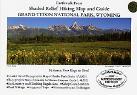
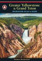
Greater Yellowstone & Grand Teton Recreation Atlas & Guide. 1:600,000 (recreation maps) and 1:100,000 (landscape maps). Benchmark Maps.
Yellowstone is the USA's first national park and combined with Grand Teton National Park, the region is unrivaled in geologic wonder, dramatic landscapes, and unique wildlife. This atlas includes:
A map and guide to National Parks & Monuments in the western United States.
12-page Recreation Guide with detailed listings of regional and park resources, campgrounds, RV parks, natural wonders, museums, trails, fishing access points, boat ramps, ski areas, and rest areas.
Recreation Maps with public lands detail for the three-state region, with road mileages.
Yellowstone NE - Tower/Canyon. 1:83,333. (TI #304).
$9.95
63-2100-303
Yellowstone NW - Mammoth Hot Springs. 1:83,333. (TI #303).
$11.95
63-2100-302
Yellowstone SW - Old Faithful. 1:83,333. (TI #302).
$19.95
63-2100-PYGT
Yellowstone and Grand Teton National Park map pack. 1:80,000 and 1:126,720. Includes 63-2100-201 Yellowstone N.P. and 63-2100-202 Grand Teton N.P. overview maps.
$32.95
63-2100-PYNP
Yellowstone N.P. Sectional Map Pack. 1:63,360. Includes 63-2100-302 Old Faithful, 63-2100-303 Mammoth Hot Springs, 63-2100-304 Tower/Canyon, and 63-2100-305 Yellowstone Lake maps.
Famous mountain benchmark paperweights and lapel pins. Whether you're a climber, hiker, geography buff, or armchair traveler, you'll love to collect or give these unique bench mark paperweights that celebrate the spirit of exploration, athletic challenge, and personal achievement. Cast in pewter these summit marker paperweights are exact replicas of official USGS benchmark markers. Please click the "sample" button below to see an enlargement of the paperweight. Each marker has a soft felt pad on the bottom so these can be used on glass, wood, or any surface. Supplied in a soft fleece drawstring pouch, 3¼" diameter.
These authentic replicas of the summit benchmarks are a great way for hikers and climbers to remember their accomplishments because they are so unique. Few people get to the top. SummitMark(tm) gifts give those who've scaled the heights another interesting way to share their treasured experience.
The lapel pins are identical to the 3" paperweights, just reduced in size to 1" for a perfect fit on anyone's lapel.
Benchmark Paperweights of US locations. Geo-Situ. Each paperweight, measuring approximately 3" in diameter, are an authentic replica of famous elevation benchmarks in the USA, and in the style of USGS benchmarks for mountains around the world, are crafted from high quality pewter for years of tarnish-free use. Each paperweigh comes in its own small fleece bag for storage, along with a small tag giving a brief description of the geographic location. All are felt-bottomed for scratch-free use on any surface.
Sample of the Grand Teton paperweight
$59.95
63-0297DE
Devils Tower benchmark paperweight. 4,250 ft.
$39.95
67-9564
Grand Teton benchmark paperweight.
$59.95
63-0297OL
Old Faithful benchmark paperweight. 7,349 ft.
Benchmark Lapel Pins for Wyoming. Geo-Situ.
These lapel pins are 1 inch in diameter, cast in fine pewter, and with a military clutch back.
$9.95
63-0297DEL
Devil's Tower, Devil's Tower National Monument, WY lapel pin. 5,112 ft.
$11.95
63-0297GTL
Grand Teton, Grand Teton National Park, WY lapel pin. 13,770 ft.
$11.95
63-0297MOL
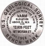
Mt. Moran, Grand Teton National Park, WY lapel pin. 12,605 ft. One of a dozen peaks over 12,000 ft. in the Teton Range.
$11.95
63-0297WAL
Mt. Washburn, Yellowstone National Park, WY lapel pin. 10,243 ft. One of the most popular hikes in Yellowstone National Park.
$11.95
63-0297OOL
Old Faithful, Yellowstone National Park, WY lapel pin. 7,349 ft.
Wyoming Wall Maps
Wyoming State and County Wall Maps. Intelligent Direct.
We offer state and county wall maps for all of the USA. The maps come in sizes from 24 x 36 to 108 x 144 inches. They are available in variety of mounting and framing options. The maps are ideal for business applications, sales territory, delivery planning, direct mail targeting and hundreds of other applications.
Click here to order county wall maps and to see sample images, descriptions, and prices.
Click here to order state wall maps and to see sample images, descriptions, and prices.
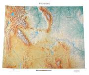
Wyoming Shaded Relief Wall Map. 1:500,000. Raven Press.
This is the state where the Continental Divide and the Rocky Mountains meet the Great Plains. Wyoming's beautiful rivers, including the Yellowstone, Platte, Green, and Snake, contrast with the rugged Rockies, especially the spectacular Big Horn Mountains. Elevations are represented by color, and this, in combination with our relief shading technique, gives the map a 3-dimensional look. Size is 42 x 52".
Thumbnail of the map. Sample of the detail.


 Sample detail from the Wyoming recreation atlas.

 Sample detail from the Wyoming recreation map.
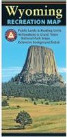
 Sample detail of the Wyoming Road Map
 Sample detail of the Wyoming Road Map
 Front of the Wyoming Road Map
 Reverse side of the Wyoming Road Map
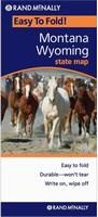 Laminated
 Sample from the Casper street map.
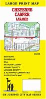
 Sample from the Casper street map.
 Front of the Casper street map.
 Reverse of the Casper street map.
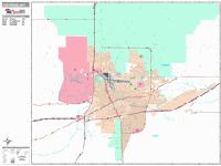
 Sample detail from the Cheyenne wall map.
 Wyoming County and State Wall Maps.

 Waterproof!
 Waterproof!
 Sample of the map detail.
 Image of the front of the map.
 Image of the reverse side of the map.
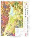
 Image of the Grand Teton geology map.
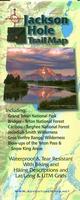 Waterproof!
 Sample detail, enlarged, from the 1:95,040 Jackson Hole Map.
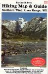 Waterproof!
 Sample from the Northern Wind River Range map
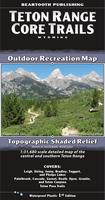 Waterproof
 Sample detail from the Teton Range hiking map.
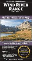 Waterproof
 Sample detail from the Wind River Range Map.
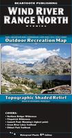 Waterproof
 Sample detail from the Wind River Range North Map.
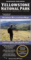 Waterproof
 Sample detail from the Yellowstone Hiing Map.
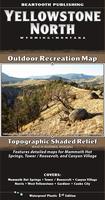 Waterproof
 Sample detail from the Yellowstone North Map.
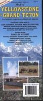
 Sample detail from the Yellowstone recreation map.
 Waterproof!
 Sample detail #1 from the Greater Yellowstone Recreational Atlas.
 Sample detail #2 from the Greater Yellowstone Recreational Atlas.
 Two-page landscape map spread from the Greater Yellowstone Recreational Atlas.
 Sample from the Mammoth Hot Springs map.
 Sample from the Yellowstone map.
 Image of the front of the Yellowstone map.
 Image of the reverse side of the Yellowstone map.
 Wyoming Hiking Map Index
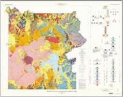
 Sample of the detail from the Yellowstone N.P. geology map.
 Image of the Yellowstone N.P. geology map.
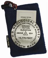
 Sample of the Grand Teton paperweight


 Thumbnail of the map.
 Sample of the detail.
 Wyoming Topographic Map. 1:500,000. 1980. USGS. Map size is 50 x 52". The official topographic map for Wyoming.