U.S. Geological Survey Historical Topographic Maps
In 1879, the USGS began to map the Nation. This mapping was done at different levels of detail, in order to support various land use and other purposes.
The first topographic map, covering Paradise, Nevada, was produced in 1882. The final 1:24,000 topographic map for the conterminous United States was produced in 1992.
As the years passed, the USGS produced new editions of most areas as well as new maps at different scales. The available maps for a particular area vary with the area within the USA. San Francisco has thirty different historic topographic maps available, dating back to 1895, while Casper Wyoming has two maps dating to 1979.
The USGS has scanned approximately 178,000 historical topographic maps at the scales of 1:24,000; 1:62,500; 1:100,000; and 1:250,000. There are an approximately 20,000 additional historic topographic maps that are waiting to be scanned and made available to the public.
These scanned maps are color-plotted to order. Many of the scanned maps include markings such as USGS library stamps, adding to their historic authenticity.
Ordering instructions:
To order historical maps, please select the current topographic map for your area of interest using the links below. When you check out, please note in the "comment" section the date range of the historic map that you want. We will let you know the closest match to your date request and the scale of the available map. You can confirm the selection before we ship your order.
Click any of the three sample buttons below to see samples from 1885, 1935, and 1947 maps.
click any of the four map images below to see coverage of the US available for each of the four date ranges.
Index Maps. Index maps for the 1:100,000 and 1:250,000 scales are available on-line for viewing. Indexes for the 1:24,000 series are available on-line for downloading to your PC. Please note that the index map files are very large and are downloaded in compressed format (.zip).
Click here for USGS 1:24,000 index maps
 U.S. Geological Survey Historical Topographic Maps
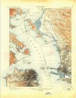
 Sample detail from the San Francisco 1885 map.
 Sample detail from the St. Louis 1935 map.
 Sample detail from the Brooklyn 1947 map.
 Click here
 Click here
 Click here
 Click here