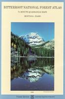
Idaho - U.S. Forest Service Maps

  • Return to Idaho maps section.


    Nez Perce National Forest map
    Ordering (ID) Boise NF map (USFS)62-64760Boise N.F. Map. Waterproof edition.$14.95
    Ordering (ID) Caribou Targhee Westside62-64761Caribou N.F. Map - Westside Ranger District. Waterproof edition.$14.95
    Ordering (ID) Caribou NF - Montpelier62-64762Caribou H.F. Map - Montpelier & Soda Springs. Waterproof edition.$14.95
    Ordering (ID) Clearwater NF map (USFS)62-64763Clearwater N.F. Map.$14.95
    Ordering (ID) Coeur dAlene N.F. map.62-64786Coeur d'Alene N.F. 1:126,720. 2003. Waterproof.$14.95
    Ordering (ID) Northern Frank Church/River of62-64765Frank Church - River of No Return Wilderness - North Half Map. Waterproof.$14.95
    Ordering (ID) Southern Frank Church/River of62-64764Frank Church - River of No Return Wilderness - South Half Map. Waterproof.$14.95
    Ordering (ID) Nez Perce NF - Gospel62-64766Gospel Hump Wilderness - Nez Perce N.F. Map.$14.95
    Ordering (ID)  Jedediah Smith & Winegar Hole62-64767Jedediah Smith and Winegar Hole Wildernesses, Targhee N.F. Map.$14.95
    Ordering (ID) Kaniksu N.F. map. 1:126,720.62-64781Kaniksu N.F. 1:126,720. 2004. Waterproof.$14.95
    Ordering (ID) Kootenai N.F. map62-78768Kootenai and East Half of Kaniksu N.F. Map.$16.95
    Ordering (MT) Lee Metcalf Wilderness map62-78881Lee Metcalf Wilderness & West Yellowstone Vicinity. 1:126,720. 2002. Waterproof.$15.95
    Ordering (ID) Middle Fork Salmon River map62-64785Middle Fork of the Salmon River. 1:62,500. 2000. A small atlas rather than normal USFS folded map. Waterproof.$14.95
    Ordering (ID) Nez Perce N.F. map. 1:126,720.62-64784Nez Perce N.F. 1:126,720. 2002. Waterproof.$16.95
    Ordering (ID) Nez Perce Historic Trail62-64783(OR/ID/MT/WY) Nez Perce (Nee-Me-Poo) National Historic Trail. 1:1,000,000. 1990. Waterproof.$14.95
    Ordering (ID) Payette NF - McCall map62-64769Payette N.F., McCall and Krassel Ranger Districts Map. Waterproof edition.$14.95
    Ordering (ID) Payette NF - Weiser map62-64770Payette N.F., Weiser, Council and New Meadows Ranger Districts Map. Waterproof edition.$14.95
    Ordering (ID) Sawtooth NF - Ketchem &62-64771Sawtooth N.F., Fairfield and Ketchum Ranger Districts Map. 1:126,630. 1998. Waterproof edition.$14.95
    Ordering (ID) Sawtooth NF - Minidonka62-64772Sawtooth N.F., Minidoka Ranger District.$14.95
    Ordering (ID) Selway-Bitterroot South62-64773Selway-Bitterroot Wilderness South Half - Nez Perce, Clearwater, and Bitterroot N.F. Map. 1:63,360. 1999. Waterproof.$15.95
    Ordering (ID) Selway-Bitterroot North62-64774Selway-Bitterroot Wilderness North Half - Nez Perce, Clearwater, and Bitterroot and Lolo N.F. Map. 1:63,360. 1999. Waterproof.$15.95
    Ordering (IL) Shawnee N.F. map.  (USFS).62-65780Shawnee N.F. 1:126,720. 2002. Waterproof.$15.95
    Ordering (OR) Snake River Boaters map (USFS)62-89844Snake River Boaters Guide & Hells Canyon map. 1:63,360. 1997.$14.95
    Ordering (ID) Idaho Pan. - St. Joe N.F. map.62-64782St. Joe N.F. 1:126,720. 2004. Waterproof.$14.99
    Ordering (ID) Targhee NF - Dubois map62-64775Targhee N.F. Map - Dubois and Island Park.$14.95
    Ordering (ID) Targhee NF - Teton Basin62-64776Targhee N.F. Map - Island Park, Ashton, Teton Basin, and Palisades.$14.95
    Ordering (ID) The Salmon Wild & Scenic62-64777The Salmon, A Wild and Scenic River Map. Waterproof edition.$14.95
    Ordering (ID) Wasatch-Cache NF - Ogden62-64778Wasatch-Cache N.F., Ogden and Logan Ranger Districts Map. Waterproof edition.$14.95


    image

  • © Copyright 2007 Omni Resources All Rights Reserved
    For more information please Contact Us