Historic Map Reproductions from NIMA, the Library of Congress, and the USGS
"Lewis and Clark: A Legacy of Science" poster. USGS, 2002. Featuring 1814 map "Lewis and Clark's Track" - a new poster from the USGS commerorates the 200th anniversary of the Lewis and Clark Trek. The poster features a beautiful reproduction of "Lewis and Clark's Track" and the same geographic area depicted with national elevation data from The National Map in a colorful image of the American landscape.
The parallel map construction illustrates how difficult Lewis and Clark's expedition was, how well they mapped the terrain, and how far cartographic techniques have advanced in 200 years. Size is 42" x 54".
63-2601
1 sheet, flat/rolled
$14.99
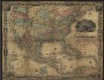
Map of the United States Showing Routes of the Principal Explorers from 1501 to 1844. USGS, 1998. Shows routes of the principle explorers in the contiguous 48 States. Follows the tracks of 16th century explorers such as Ponce de Leon and Sir Francis Drake, American trailblazer John C. Fremont, and the Lewis Clark expedition of 1894-06. Backgrounds features include international and State boundaries and names; State capitals and major cities; rivers and lakes.
Image of the entire map
62-2038
1 sheet, flat/rolled
$9.95
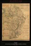
Antietam. NIMA. One of a series of 14 maps based on surveys of the Antietam Battlefield showing military positions during the course of the battle. The originals are located at the Antietam National Battlefield.
These maps were created in response to a congressional mandate to document significant Civil War battlefields. The purpose was to gain a greater understanding of the movement of troop, artillery and cavalry units as they maneuvered to win an advantage. In the end, the opposing forces became bogged down ending in a stalemate. Information is depicted on this map just as modern day Geospatial Intelligence products are used today.
63-2602
1 sheet, flat/rolled
$14.99
D-Day. NIMA. This site has the entire series of HQ Twelfth Army Group situation maps depicting the position of the 12th Army Group and adjacent Allied Forces and of the German units for each day from D-Day (6 June 1944) thru 26 July 1945.
63-2604
1 sheet, flat/rolled
$14.99
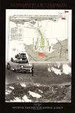
Normandy Air Campaign. NIMA. P-47 fighter-bombers, along with other planes such as the Hawker Typhoon, formed an intimate partnership with allied ground forces during the Normandy Campaign.
Through close communication with mobile air-ground control posts known as "contact cars" that accompanied leading armored forces, aircraft pilots were kept informed of enemy and friendly ground locations. This information exchange helped pilots execute precision air strikes on waiting German forces and significantly reduced the chance of allied troops falling victim to friendly air fire.
63-2605
1 sheet, flat/rolled
$14.99
Philippines. NIMA. This map shows the totality of air and sea battles during the second Philippine campaign, when the US regained control of the islands from the Japanese. The map displays the Japanese routes the Americans had to cut to achieve victory.
Image shows the U.S.S. Hornet from US Navy Site http://www.navy.mil . The site contains histories and photos of Navy ships. Aircraft from the Hornet were used for photo reconnaissance prior to the invasion of Okinawa. Original map is a captured Japanese map, housed at the National Archives, Washington D.C.
63-2606
1 sheet, flat/rolled
$14.99
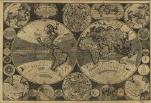
1702 - A New and Correct Map of The World. USGS & Library of Congress. Map originally sold by Willdey at ye Great Toy & Print Shop ye corner of Ludgate Street next So. Pauls Church Yard London, 1702 (Reproduction.).
63-2608
1 sheet, flat/rolled
$24.95
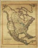
1849 - Map of North America. USGS & Library of Congress. Map of North America including part of the West India Islands. Published by C. Smith, Mapseller, London, 1849. Colors are used to outline boundaries. (Reproduction.) Actual Size: 30" x 38"
63-2609
1 sheet, flat/rolled
$39.95
1857 - Map of the United States. USGS & Library of Congress. Map of the United States of America, The British Provinces, Mexico, The West Indies and Central America with part of New Grenada and Venezuela. Published by J.H. Colton and Co., New York, 1857. Two insets show: A map of the Atlantic Ocean showing the American and European ports; The Isthmus of Panama. (Reproduction.) Size: 51¾" x 40."
63-2610
1 sheet, flat/rolled
$24.95
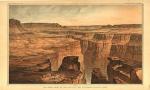
1882 - The Grand Cañon At The Foot of The Toroweap - Looking East. USGS & Library of Congress. This panoramic view of the Grand Canyon by William H. Holmes was published in Clarence E. Dutton's 1882 "Atlas to Accompany the Monograph on the Tertiary History of the Grand Cañon District."
Holmes was the scientific illustrator of topographic and geologic phenomena for the Great Western Surveys following the Civil War. (Reproduction.) Size: 32¾" x 19½."
63-2611
1 sheet, flat/rolled
$37.95
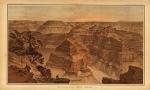
1882 - Panorama From Point Sublime. USGS & Library of Congress. This panoramic view of the Grand Canyon by William H. Holmes was published in Clarence E. Dutton's 1882 "Atlas to Accompany the Monograph on the Tertiary History of the Grand Cañon District."
Holmes was the scientific illustrator of topographic and geologic phenomena for the Great Western Surveys following the Civil War. (Reproduction.) Size: 32¾" x 19½."
63-2612
1 sheet, flat/rolled
$29.95
1894 - Historic Map of Colorado. USGS & Library of Congress. Looking for an attractive historical map of Colorado? Reproduced by USGS in cooperation with the Library of Congress, this map was originally published in 1894 by James McConnell School Supplies of Denver, Colorado. This unique birds-eye view map has incredible detail and is ideal for framing. Features include: relief shading, counties, cities, towns, roads, rivers, valleys, railroads, and elevations of some mountain peaks. It is interesting to note how some features' names and spellings have changed since 1894. The map is scaled at approximately 1:500,000. Size: 39" x 56".
63-2613
1 sheet, flat/rolled
$19.95
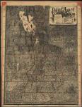
1895 - Relief Map of Utah. Published by Pierce & McMillen, Salt Lake City, 1895. Drawn by Mosiah Hall, Superintendent of Schools, Weber County, and assisted by Charles Wright. County borders and minerals are illustrated on the map in red. Also included are demographics about the state and a statement that the map was "Designed for the home, the office, and especially for Schools." (Reproduction.) Size: 40" x 51½."
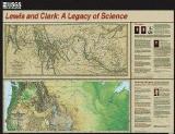


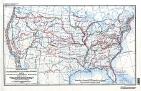
 Image of the entire map