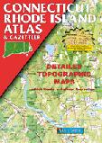
Connecticut & Rhode Island Atlas and Gazetteer. DeLorme. Excellent road atlas with topographic maps and gazetteer.
$29.95
62-5848
Atlas
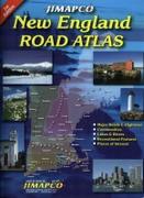
New England Road Atlas. Jimapco. This spiral bound road atlas of New England covers Maine, New Hampshire, Vermont, Massachusetts, Connecticut, and Rhode Island. Includes major roads and highways, communities, lake & rivers, recreational features, and places of interest.
$29.95
62-20959
Atlas.
Rhode Island Road Maps
Rhode Island Road Maps - Paper
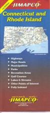
Rhode Island & Connecticut Road Map. Jimapco. State map of Connecticut & Rhode Island. Expanded coverage for Greater Hartford, Providence and the coastline. Street level detail for Providence, New Haven and Hartford. Includes parks, recreation area, golf courses, lakes, streams and other points of interest. Fully indexed. Map size is 38? x 25.5? unfolded.
Sample detail of teh Rhode Island road map. Sample detail of teh Rhode Island road map.
$6.95
62-58904
1 sheet, folded
Rhode Island & Connecticut Road Map - Paper. Rand McNally. Rand McNally's Easy To Read State Folded Map is a must-have for anyone traveling in and around Connecticut and Rhode Island, offering unbeatable accuracy and reliability at a great price. Our trusted cartography shows all Interstate, U.S., state, and county highways, along with clearly indicated parks, points of interest, airports, county boundaries, and streets.
The easy-to-use legend and detailed index make for quick and easy location of destinations. The map includes inset maps of Bridgeport/New Haven, CT; Fall River, MA; Hartford, CT; New London, CT; Newport, RI; Providence, RI; Stamford, CT; Springfield, MA; Waterbury, CT. Map size is 28 x 40" unfolded.
Rhode Island Road Maps - Laminated
Laminated Rhode Island & Connecticut Easyfinder® Road Map. Rand McNally. The durable and convenient Connecticut and Rhode Island EasyToFold state map will take all the wear and tear your journey can dish out. The heavy-duty laminated design allows you to mark your route, make notes, then wipe the surface clean for further use. This is a must-have for navigation whether you're a state resident or just passing through. size is 18 x 17" unfolded.
$9.99
62-58902
1 sheet, folded
Rhode Island City Street Maps
Rhode Island City Street Maps - Paper
Rhode Island City Street Maps - Paper. Various publishers.
These are full-sized folded paper street maps, generally slightly more detailed and a larger coverage area than the laminated maps below.
$5.95
62-9192NE
Newport City, Newport & Bristol Counties Street Map. (GM Johnson). The Newport City and Newport & Bristol Counties map also includes coverage of Barrington, Bristol, Jamestown, and adjoining Communities.
$6.95
62-9192PR
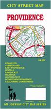
Providence Street Map. (GM Johnson). The map also covers Cranston, Cumberland, Lincoln, and adjoining Communities
$6.99
62-9192P
Providence & Newport Street Map. (Rand McNally). This detailed map of Providence and Newport, Rhode Island has complete coverage for the city and surrounding area, with an inset map for downtown, plus most major tourist and business districts. When you flip the map over, you will find a complete street index and a "city and vicinity" map of the entire metro area.
Rhode Island City Street Maps - Laminated
Laminated Providence, Cranston & Newport laminated street map. American Map.
This waterproof map of Providence, Cranston, and Newport, RI is tear-resistant and 100% recyclable. Coverage includes insets of Downtown: Cranston and Providence; and the Newport city area; and features: Airports, Colleges and Universities, Golf Courses, Hospitals, Parks and Rec Areas, Places of Interest, and ZIP Codes
$8.99
62-91921PR
1 sheet, folded.
Rhode Island City, County, and State Business Wall Maps
Rhode Island City Wall Maps.
When it comes to general planning, defining delivery areas, planning direct marketing and delivering products, our city wall maps are perfect to get the detailed information you need.
These maps offer clear mapping by showing all major streets and roads, but leaving out the smaller streets.
If you want a clear map for easy planning, then these are the maps for you; if you want a map showing every little back alley, these are not for you.
We offer wall maps for Cranston, East Providence, Pawtucket, Providence, and Warwick.
We offer state and county wall maps for all of the USA. The maps come in sizes from 24 x 36 to 108 x 144 inches. They are available in variety of mounting and framing options. The maps are ideal for business applications, sales territory, delivery planning, direct mail targeting and hundreds of other applications.
We stock all USGS topographic maps of Rhode Island at all available scales.
Rhode Island Wall Maps
Rhode Island State and County Wall Maps. Intelligent Direct.
We offer state and county wall maps for all of the USA. The maps come in sizes from 24 x 36 to 108 x 144 inches. They are available in variety of mounting and framing options. The maps are ideal for business applications, sales territory, delivery planning, direct mail targeting and hundreds of other applications.
Click here to order county wall maps and to see sample images, descriptions, and prices.
Click here to order state wall maps and to see sample images, descriptions, and prices.
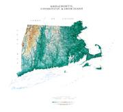
Massachusetts & Connecticut & Rhode Island Shaded Relief Wall Map. 1:500,000. Raven Maps. Our map of southern New England places three historic states together. Elevations are represented by color, and this, in combination with our relief shading technique, gives the map a 3-dimensional look. Size is 81 x 91 cm (32 x 36").
Thumbnail of the map. Sample of the detail.
$40.00
62-7351
Each, flat
$65.00
62-7351L
1 sheet, flat, laminated
Shipwrecks of the Northeast USA Chart. 1:700.000. National Geographic Maps, 2011. "Shipwrecks of the Northeast" is a stunning new map illustrating more than 5,400 known shipwrecks on the untamed Atlantic coast of New England (Maine, Massachusetts, New Hampshire and Rhode Island). From Rhode Islands' Narragansett Bay to Maine's St. Croix River, the shipwrecks are clearly marked atop beautiful bathymetric and coastal detail. Each wreck site is symbolized to define the class, type and name of vessel accompanied by the date of sinking. Icons also indicate whether a ship was lost due to conflict or natural causes. Size is 28 x 36 inches.
Image of the Shipwrecks of the Northeast USA map Sample of the Shipwrecks of the Northeast USA map
$19.99
62-1718
1 sheet flat
$29.99
62-1718L
Laminated.
United States Lighthouses Map. Bella Terra. Map size, unfolded/flat, is 39 x 27 inches.
The most up-to-date and comprehensive U.S. lighthouse directory.
All 770 standing lighthouses in the 50 states located on detailed regional maps--including Lake Havasu, AZ/CA.
Each official lighthouse name, alternate names, year of first lighting, year of current structure, physical location & latitude/longitude.


 Sample detail of teh Rhode Island road map.
 Sample detail of teh Rhode Island road map.
 Laminated
 Laminated
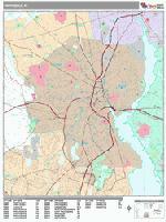
 Sample detail from the Providence wall map.
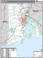 Rhode Island County and State Wall Maps.

 Thumbnail of the map.
 Sample of the detail.
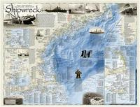
 Image of the Shipwrecks of the Northeast USA map
 Sample of the Shipwrecks of the Northeast USA map
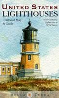
 Sample detail of the USA Lighthouses Map
 Rhode Island Flags