Indian Country map. National Geographic Maps. For five centuries, Indian territories have been contested on battlefields, legislated in Congress, and studied in classrooms. This updated map shows Indian reservations, tribal entities, trust lands, and locations of major festivals and pow-wows. Also includes photos and short biographies of notable Indians through history, and a series of four maps showing how Indian lands have lost territory from 1775 to the present. An excellent complement to our Indian Cultures of North America map.
Measures 36" x 23".
Image of the entire map. Sample #1 of the map detail. Sample #2 of the map detail.
62-19449
1 sheet, flat.
$12.99
62-19449L
1 sheet, laminated.
$33.99
North American Indian Cultures Reference Map. National Geographic Maps. A legacy of language and inspired ideas is explored in this compelling North American Indian Cultures map. The map shows a broad sampling of linguistic families throughout the continent along with descriptions of each language group. A special inset highlights Indian innovations from parkas and snow goggles to new medicines and agricultural techniques. A perfect complement to our Indian Country map. Measures 36" x 23".
Image of the entire map. Sample #1 of the map detail. Sample #2 of the map detail.
62-19450
1 sheet, flat.
$12.99
62-19450L
1 sheet, laminated.
$19.99
US Federal and Indian Lands Map. 1:7,500,000. USGS, 1998. This map shows federal administration and trusteeship of principal land units by agency. Bureau of Indian Affairs lands are not public lands, but are held in trust for American Indian and Alaska Native tribes.
These Indian lands are enclosed by boundaries established by treaties or proclamations. Inset maps show federal lands in Alaska and Hawaii. From the National Atlas of the United States. Size is 19-1/2" x 29", flat.
Image of the entire map
62-19453
Set, folded
$10.00
Indian Lands Area. 1:5,000,000. USGS, 1992. Federal Indian reservations, state reservations, federal Indian groups without reservations, Bureau of Indian Affairs areas and offices, and interstate highways are shown on this map.
Rivers and lakes are clearly illustrated. Inset map shows Alaska. Compiled from the Handbook of North American Indians in cooperation with the Bureau of Indian Affairs. Size is 26" x 42", flat.
Image of the entire map
62-19454
Set, folded
$10.99
Indian Land Areas Judicially Established. 1:3,168,000. USGS, 1978, reprinted 1993. This large, colorful map shows the results of cases before the U.S. Indian Claims CommissionU.S. Court of Claims in which American Indian tribes proved its original tribal occupancy of a tract within the continental United States.
Inset provides additional details of the Pacific Northwest region. Prepared under the direction of the Indian Claims Commission as part of its final report. Size 38" x 51", flat.
Thumbnail image
62-19455
Set, folded
$10.00
Indian Tribes, Cultures, and Languages. 1:7,500,000. USGS, 1967. Illustrates the geographic extent of the various major and minor Indian tribes, their cultural areas, and 18 Indian linguistic stocks, both in the conterminous 48 states and Alaska. A short text and reference list are printed on the back.
From the National Atlas of the United States.
Image of the entire map
62-19456
Set, folded
$10.00
Indian Lands in the United States. 1:5,000,000. USGS, 1998. Colorful shaded relief map of the conterminous 48 states showing 1998 American Indian Geographic Entities. American Indian Reservations (AIR's) are legal entities having boundaries established by treaty, statute, and/or executive court order.
Tribal Designated Statistical Areas (TDSA's) are geographic areas delineated for 1990 census data tabulation purposes by tribal officials of federally and state-recognized tribes outside of Oklahoma that do not have a legally defined reservation or associated trust lands. Size is 31" x 44", flat.
Image of the entire map
Indians of North America. An illustrated ethnological map, color-coded to show native locations of different tribes. Size is 33" x 38".
Thumbnail view of the front of the map.
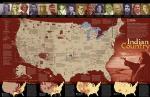
 Image of the entire map.
 Sample #1 of the map detail.
 Sample #2 of the map detail.
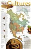
 Image of the entire map.
 Sample #1 of the map detail.
 Sample #2 of the map detail.
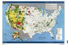
 Image of the entire map
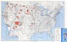
 Image of the entire map
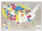
 Thumbnail image
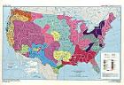
 Image of the entire map
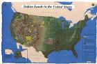
 Image of the entire map
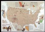
 An image of the full map
 A detail of the map
 A sample of the legend
 Thumbnail view of the front of the map.