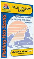
Tennessee Fishing Maps by Fishing Hot Spots are superb maps showing the lake bottoms for hundreds of lakes and rivers across the USA. These maps are printed on either kimdura or Hop-syn (both tear-resistent waterproof synthetic materials), making them nearly indestructible. These maps, often called lake bottom maps or lake contour maps, show lake bottom contours, shoreline features, roads leading to the lakes, boating facilities along the lake shore, and much more.
Fishing Map sample Enlargement
$14.95
62-6993-L112
Lake Barkley-North (Barkley Dam to Hwy 68/80 Bridge) (KY/TN) fishing map.
$14.95
62-6993-L113
Lake Barkley-South (Hwy 68 Bridge to Dover, TN) (KY/TN) fishing map.
$14.95
62-9493-A400
Center Hill Lake fishing map.
$14.95
62-9493-A401
Cherokee Lake fishing map.
$14.95
62-9493-A402
Lake Chickamauga fishing map.
$14.95
62-9493-L119
Dale Hollow fishing map.
$14.95
62-9493-A404
Douglas Lake fishing map.
$14.95
62-6993-L121
Kentucky Lake-Central (Blood River to Big Sandy) (KY/TN) fishing map.
$14.95
62-6993-L120
Kentucky Lake-North (Kentucky Dam to KY/TN Line) (KY/TN) fishing map.
$14.95
62-9493-L736
Fort Loudoun Reservoir fishing map.
$13.95
62-9493-A405
Nickajack Lake fishing map.
$14.95
62-9493-A406
Norris Lake fishing map.
$14.95
62-9493-A407
Old Hickory Lake fishing map.
$14.95
62-9493-A408
J.Percy Priest Lake fishing map.
$14.95
62-9493-A409
Reelfoot Lake fishing map.
$14.95
62-9493-L735
Tellico Lake fishing map.
$14.95
62-9493-A410
Tims Ford Lake fishing map.
$14.95
62-9493-A411
Watts Bar Lake fishing map.
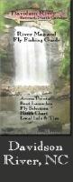
Fishwater Fishing Maps for NC and TN. C.S. Gibbs Design. The maps measure 11 x 17 inches and are printed on waterproof, tear resistant synthetic paper. They are finely crafted, highly graphic and completely functional. Each map features a hatch chart and recommended fly selection as well as other important information about the river and area. The maps also feature photographs of the river, and information to help you find local food and lodging.
Index map showing locations of the fishing maps.
$10.99
62-94933-CLI
Clinch River Fishing Map. Clinton, Tennessee.
$10.99
62-85933-DA
Davidson River, NC fishing map. The Davidson River is a freestone stream flowing out of the lush Pisgah National Forest. It is consistently rated as a top 100 trout stream by Trout Unlimited and much of its length is catch and release only fishing.
$10.99
62-85933-FR
French Broad River, NC fishing map. This river map and fly fishing guide shows approximately 30 miles of The French Broad River as it flows through Asheville, NC as well as important tributaries. This stretch of The French Broad offers prime smallmouth bass fishing and canoeing.
$10.99
62-85933-FRU
French Broad River - Upper section, NC fishing map. The Upper French Broad River is a convergence of the four branches and a transition from tumbling mountain streams to medium sized river. The map shows all four branches from their headwaters to their convergence, and approx 27 miles of The French Broad River.
$10.99
62-94933-HI
Hiwassee River, TN fishing map. The Hiwassee is a big tailwater close to the NC/TN/GA border. The mix of cold water and mild climate make it a wonderful year round fishery and its wide open character make it a perfect river to float.
$10.99
62-94933-LIT
Little River Fishing Map. Townsend, Tennessee.
$10.99
62-85933-MI
Mills River, NC fishing map. Near Mills River, NC, the Mills River map consists of both the North and South Forks and the Mills River proper to its convergence with the French Broad. The North Fork is a heavily stocked stream and is managed as Delayed Harvest, while the South Fork is one of the state's largest wild trout rivers.
$10.99
62-85933-NA
Nantahala River fishing map. The Nantahala River is a beautiful tailwater fishery in far western NC and has been rated as a top 100 Trout stream by Trout Unlimited.
$10.99
62-85933-NTL
North Toe River - Lower section, NC fishing map. The Lower North Toe River is a top shelf smallmouth bass fishery and a fantastic river to float in either a canoe, drift boat, or personal watercraft. The map shows the river from Spruce Pine to the confluence with the South Toe where the river becomes the Nolichucky.
$10.99
62-85933-NTU
North Toe River - Upper section, NC fishing map. The Upper North Toe River is a medium sized, freestone river providing many trout fishing opportunities in its watershed. The map shows the river from its headwaters to the town of Spruce Pine and includes the Delayed Harvest Section. It has all the info you need to get on the water, including hatch charts, recommended flies, access points and local info.
$10.99
62-94933-SH
South Holston River, TN fishing map. The South Holston Tailwater is arguably the finest cold water fishery in the south. Wild brown trout are the predominate species and 20 plus inch fish are common, with behemoths up to 10 plus pounds caught every season.
$10.99
62-85933-TU
Tuckasegee River, NC fishing map. The Tuckasegee Tailwater is a wide open river with quality trout habitat and includes a popular Delayed Harvest Section. The lower portion of the river, from Dillsboro to Bryson City provides great smallmouth bass fishing. The map shows the river from the dam to Bryson City, NC.
$10.99
62-85933-TUL
Tuckasegee River - Lower section, NC fishing map. The Lower Tuckasegee River, from Dillsboro to Bryson City provides great smallmouth bass fishing. It is a wide open river great for wet wading on a hot summer day. The map shows the river from the Dillsboro to Bryson City, NC.
$10.99
62-85933-TUU
Tuckasegee River - Upper section, NC fishing map. The Upper Tuckasegee Tailwater is the most heavily stocked stretch of river in North Carolina. It is a wide open river with quality trout habitat and includes a popular Delayed Harvest Section.
$10.99
62-94933-WA
Watauga River, TN fishing map. The Watauga River, or Wilbur Tailwater, is a premier cold water fishery in Eastern Tennessee. The river is renowned for it's heavy caddis hatches in the spring and provides quality fishing year round. The map shows the river from above Wilbur Dam to Boone Lake.
$10.99
62-85933-WI
Wilson Creek, NC fishing map. Near Edgemont/Morganton, NC, Wilson Creek is a freestone stream flowing out of the Wilson Creek Wilderness Area. It was recently named a Wild and Scenic River and beginning in Oct 2009, will become one of the most heavily stocked trout streams in the state with the opening of the new Delayed Harvest Section.
$10.99
62-85933-WR
Wrightsville Beach, NC fishing map. Wrightsville Beach is a popular destination for summer beach goers and provides some great opportunities for fly casters.
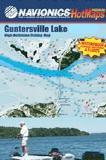
Navionics Fishing Maps. Using advanced computerized hydrographic survey technology, Navionics collected thousands of man-hours of data including water depth, lake bottom characteristics, sonar imagery and global positioning points for selected lakes across the country. The data, ranging from several hundred thousand to several million data points per map, is edited to create highly detailed lake bottom fishing maps.
Features of the lake maps.
Color shaded depth contours.
Major routes and highways.
Double-sided with detailed area insets.
Area points-of-interest.
Top-down satellite photo overlay.
Tear resistant.
3D lake overview.
Water resistant or water proof.
Measures approximately 24" x 36" - folds to small booklet size.
Most popular lakes have multiple sheets for the most detailed coverage.
Buy
Sample
Catalog #
Title
Price
62-94932-CH
(TN) Cherokee Lake fishing map set. 2 sheets.
$29.99
62-94932-PR
(TN) J. Percy Priest Reservoir fishing map.
$19.99
62-94932-WA
(TN) Watts Bar Lake fishing map set. 3 sheets.
$34.95
Tennessee Fishing Maps by A.I.D. Assoc. These maps are well researched to show accurately underwater details, including ponds, creeks, ridges, valleys, trees, roads, and cemeteries.
Full-color photographs and information on the map tell you what resorts, marinas, motels, bait and tackle stores, restaurants, and other businesses in the area have to offer and how to phone ahead for reservations. The maps below are printed on waterproof synthetic paper. The maps have a 60-second latitude/longitude grid.
Sample #4. Sample from the Red River, Louisiana map.
$12.95
62-94931-CH
Chickamauga fishing map.
Tennessee Fishing Maps by Kingfisher Maps. These maps show the topography of the lakebottoms and locations of shore facilities and lake buoys. Folded maps printed on Polyart synthetic "paper," making them nearly indestructible. All maps have GPS coordinate information unless noted otherwise.
$12.99
62-9493-CJ
Lake Chicamauga fishing map.
$12.99
62-9493-CO
(TN) Cordell Hull fishing map. 1:37,318. Single-sided, 23" x 35".
$12.99
62-9493-JP
J. Percy Priest fishing map.
Tennessee's Rivers Fishing Maps by Wilderness Adventures Press. An essential tool for a successful fly-fishing trip is a detailed map of the water. One that will give you the access points, boat launches, campgrounds, public areas, roads, and GPS coordinates to pinpoint your location.
 Tennessee Fishing Maps by Fishing Hot Spots are superb maps showing the lake bottoms for hundreds of lakes and rivers across the USA. These maps are printed on either kimdura or Hop-syn (both tear-resistent waterproof synthetic materials), making them nearly indestructible. These maps, often called lake bottom maps or lake contour maps, show lake bottom contours, shoreline features, roads leading to the lakes, boating facilities along the lake shore, and much more.
 Fishing Map sample
 Enlargement
 Index map showing locations of the fishing maps.


 Sample #4.
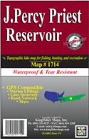 Tennessee Fishing Maps by Kingfisher Maps. These maps show the topography of the lakebottoms and locations of shore facilities and lake buoys. Folded maps printed on Polyart synthetic "paper," making them nearly indestructible. All maps have GPS coordinate information unless noted otherwise.


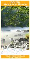
 Front of the South Holston fishing map
 Sample detail from the front of a river map from this series (Deschutes River)
 Sample detail from the back of a river map from this series (Truckee River)
 Sample detail #2 from the back of a river map from this series (Metolius River)