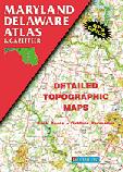
Delaware & Maryland Atlas and Gazetteer. 1:100,000. DeLorme.
Excellent road atlas with topographic maps and gazetteer.
$29.95
62-7248
Atlas
Delaware & Maryland Road Atlas. ADC.
The Maryland / Delaware Street Atlas includes: Maryland's Annapolis, Baltimore, Cumberland, Frederick, Gaithersburg, Hagerstown, and Rockville; and Delaware's Dover, Newark, and Wilmington; and an inset of Washington, DC; and features: Detailed Places of Interest, Detailed State Parks and Rec Areas, Golf Course Information, and Vineyards and Wineries.
$22.99
62-7290
Atlas
Delaware Road Maps - Paper Maps
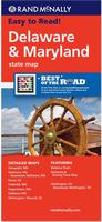
Delaware & Maryland Road Map. Rand McNally.
Detailed road map covering both states. With index of cities/towns. Includes several inset maps of major cities in Maryland and Delaware.
$7.99
62-72904
1 sheet, folded.
Delaware & Maryland Road Map. 1:594,000. American Map.
Detailed road map covering both states. With index of cities/towns. Includes several inset maps of major cities in Maryland and Delaware.
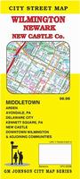
Wilmington, Newark, and New Castle County street map. (GM Johnson).
Delaware City Street Maps - Laminated.
$8.99
62-59921DE
Delaware Shores street map - laminated. (American Map).
Delaware Street Atlases
Delaware City and County Street Atlases. ADC/Kappa Map Group. Unfortunately Kappa is letting some of these classic ADC street atlases go out of print.
$21.99
62-5991N
New Castle County Street Atlas. (ADC).
$22.99
62-5991SU
Sussex County Street Atlas. (ADC).
Delaware City Wall Maps
Delaware City Wall Maps.
When it comes to general planning, defining delivery areas, planning direct marketing and delivering products, our city wall maps are perfect to get the detailed information you need.
These maps offer clear mapping by showing all major streets and roads and many of the smaller streets, but leaving out the smallest streets. If you want a clear map for easy planning, then these are the maps for you; if you want a map showing every little back alley, these are not for you.
We offer wall maps for Wilmington.
Click here to see sample images, prices, sizes, and mounting options.
We stock all USGS topographic maps of Delaware at all available scales.
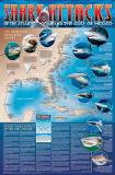
A great gift for the shark enthusiast! Shark Attack Poster of the Atlantic Ocean and the Gulf of Mexico. Sealake Products. This fascinating, educational print shows the locations of over 300 shark attacks in the Atlantic and Gulf of Mexico from 1905 to the present. 35 hair-raising encounters
are detailed, including the 1916 attacks in New Jersey. Plus, you'll learn interesting facts about the 12 types of sharks blamed for the attacks. Also, an actual size tooth from each of the three most dangerous sharks is shown. Size is 24 x 36". Available rolled/flat, either as plain paper or laminated.
Mid-Atlantic Lighthouses Map. Bella Terra Publishing. This map shows all standing and "lost" lighthouses in New Jersey, SE Pennsylvania, Delaware, Maryland, and Virginia. The base map is a shaded relief map, and the map size is 36 x 24 inches.
30 original watercolor illustrations
History & description of each lighthouse
Directions to view each standing light
Locations & directory of Lighthouse & Maritime Museums
Delmarva Peninsula Map (Delware-Maryland-Virginia). 1:250,000. National Geographic Maps/Trails Illustrated #772. The new Delmarva Trails Illustrated regional topographic recreation map covers all major recreation areas for the Peninsula and Chesapeake Bay region.
This beautifully designed map includes all state parks, state wildlife areas, national wildlife areas and key recreation access points. Locations for camping, boating, canoeing/kayaking, hunting, biking/greenways, and fishing are displayed. Highlights include Blackwater and Chincoteague National Wildlife Refuges, Assateague Island National Seashore, Cape Henlopen State Park, and Maryland's Eastern Shore. This map will be an essential trip planning tool, road map, and on-the-ground guide for accessing Delmarva Peninsula's public lands. Map size is 25-1/2 x 37-3/4".
Index of map coverage Thumbnail of the front of the map. Thumbnail of the reverse of the map Detail from the map.
$14.95
63-2100-772
1 sheet, folded.
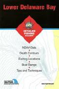
Shipwrecks of the Delmarva Peninsula Chart. 1:414,500. National Geographic Maps, 2010. Shipwrecks of Delmarva shows the location of over 2,400 wrecks from the waters off the Delaware coast to the waters of the Chesapeake Bay, displayed atop beautiful bathymetric and coastal detail. Each wreck site is symbolized to define the class, type, and name of vessel accompanied by their dates of sinking. Locations of lifesaving stations, lighthouses and lightships, along with navigational beacons are accurately marked. Bathymetric and coastal features are clearly labeled, accompanied by inset maps, captions, and drawings used to highlight unique historical events such as the sinking of the U.S.S. Cumberland, the German U-Boat offensives, and the ghost fleet of Mallows Bay - the largest assemblage of wooden ships in the Western Hemisphere. Size is 28 x 35 inches.
Image of the Shipwrecks of the Delmarva map Sample of the Shipwrecks of the Delmarva map
$19.99
62-7283
1 sheet folded
Delaware Wall Maps
Delaware State and County Wall Maps. Intelligent Direct.
We offer state and county wall maps for all of the USA. The maps come in sizes from 24 x 36 to 108 x 144 inches. They are available in variety of mounting and framing options. The maps are ideal for business applications, sales territory, delivery planning, direct mail targeting and hundreds of other applications.
Click here to order county wall maps and to see sample images, descriptions, and prices.
Click here to order state wall maps and to see sample images, descriptions, and prices.
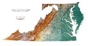
Virginia/Delaware/Maryland Raven State Wall Map. 1:500,000. Raven Press.
This beautiful regional map is centered on the Chesapeake Bay area. Elevations are represented by color, and this, in combination with our relief shading technique, gives the map a 3-dimensional look. 34 x 65".
Thumbnail of the map. Sample of the detail.


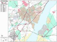
 Front of the Wilmington map.
 Sample detail from the Wilmington map.

 A great gift for the shark enthusiast!
 Image of the entire poster
 Sample of the map detail, covering Florida.
 Sample of the Great White Shark text.
 Sample of the text describing the attacks.
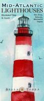
 Image of the entire Mid-Atlantic Lighthouses map.
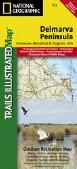
 Index of map coverage
 Thumbnail of the front of the map.
 Thumbnail of the reverse of the map
 Detail from the map.
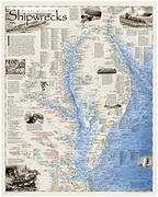
 Image of the Shipwrecks of the Delmarva map
 Sample of the Shipwrecks of the Delmarva map
 Delaware State and County Wall Maps. Intelligent Direct.
 Thumbnail of the map.
 Sample of the detail.
 Thumbnail of the Delaware topographic wall map.