Blue Ridge Parkway Travel Maps. Scale approximately 1:135,000. Outdoor Paths Publishing. These are two sided folded, full color, relief maps. They are designed to act as your guide as you travel the Parkway. Each map show Visitor Centers, trailheads, campgrounds, overlooks, tunnels and access roads.
In addition, major recreation areas, Forest Service campgrounds, and waterfalls are shown. Plus, many backroads are detailed making this map an invaluable guide to scenic drives as well as a recreational resource for areas surrounding the Parkway.
Sample detail of the Blue Ridge Parkway Map Sketch map showing coverage of each Blue Ridge Parkway map
62-2160N
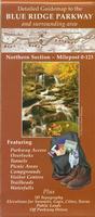
Blue Ridge Parkway Map - Northern Section. 2007. Covers the Parkway from Milepost 0 to Milepost 123 (northern end to Roanoke).
$9.95
62-2160C
Blue Ridge Parkway Map - Central Section. 2007. Covers the Parkway from Milepost 123 to Milepost 289 (Roanoke to Boone).
$9.95
62-2160S
Blue Ridge Parkway Map - Southern Section. Covers the Parkway from Milepost 289 to Milepost 469 (Boone to Great Smoky Mtns National Park/southern end).
$9.95
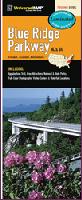
Blue Ridge Parkway Travel Map, NC and VA - laminated. Universal Map. This map of the Blue Ridge Parkway, in North Carolina and Virginia, is durably laminated and contains extensive coverage. Coverage includes: the Appalachian Trail, Area Attractions, National and State Parks, full-color photographs, Visitor Centers, and Waterfall locations. Laminated maps are easy to fold, write on, and wipe off.
 Sample detail of the Blue Ridge Parkway Map
 Sketch map showing coverage of each Blue Ridge Parkway map