Ordesa Raised Relief Map. IGN. Size is 9 x 13 inches. In Spanish.
$19.95
65-32775
Raised relief map
Oviedo Municipal Area Raised Relief Map. 1:65,000. IGN. Size is 17-1/2" x 12-1/2". In Spanish.
$29.95
65-32777
Raised relief map
Val d'Aran Raised Relief Map. A map of this popular national park in Spain. This is a detailed map showing villages, roads, glaciers,and more. The map has nearly 3 inches of vertical relief with shading to show vegetation. Size is 24 x 27 inches. In Spanish.
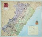
 Thumbnail of the map.
 Detail from the map.