For over 85 years National Geographic has mapped the world, setting the standard in cartographic excellence. From the remote jungles of Africa to the far reaches of the Universe, their extensive line of reference and wall maps is your key to discovering more about our world.
The National Geographic Maps listed below are available as plain paper maps, laminated maps, or mounted on wood material with beveled edges. These mounts are available in four colors - woodgrain, black, white, and gold. This style of mounting is a sturdy, attractive way to display and preserve your map - ideal for home or school. Note that the typical map pin does not work with this type of mounting - map pins require a foam-core type backing.
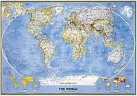
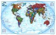
Colorful and bold - countries easily identified. Enjoy the accuracy and beauty of the latest world map from the cartographers at National Geographic. This map features the Winkel Tripel projection. The Decorator map has spectacular color and detail to bring the world alive. Ideal for home, office, or school.
Thumbnail of the entire map Sample map detail #1 Sample map detail #2 An enlarged view of the mounted map
67-10536
World Political Map, Winkel projection. 1:38,931,000. 46 x 30".
$16.99
67-10536L
World Political Map, laminated.
$29.95
67-10536BL
World Political Map, regular size - mounted, black.
$199.95
67-10536GO
World Political Map, regular size - mounted, gold.
$199.95
67-10536WH
World Political Map, regular size - mounted, white.
$199.95
67-10536WO
World Political Map, regular size - mounted, wood-grain.
$199.95
67-10537
World Political Map, Winkel projection - large size. 1:24,000,000. 73 x 48".
$34.99
67-10537L
World Political Map - large size, laminated.
$59.99
67-10537BL
World Political Map, large size - mounted, black.
$499.95
67-10537GO
World Political Map, large size - mounted, gold.
$499.95
67-10537WH
World Political Map, large size - mounted, white.
$499.95
67-10537WO
World Political Map, large size - mounted, wood-grain.
$499.95
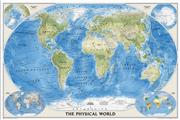
Classic National Geographic World Map! World Political Map. This famous map features the Robinson projection, which minimizes distortion relative to shapes, distances and perspective. Insets of physical hemispheres, polar views, vegetation and land use, and population density. Available in three sizes.
Standard size - 43-1/2" x 30-1/4". Huge size - 71-1/4" x 50". Mural size - 110" x 76" (9' 2" x 6' 4"). An image of the full map A detail of the map A sample of the legend An enlarged view of the mounted map
67-10530
Standard size - 43-1/2" x 30-1/4". Rolled.
$14.99
67-10530L
Standard size - laminated.
$24.99
67-10530BL
Standard size - mounted, black.
$199.95
67-10530GO
Standard size - mounted, gold.
$199.95
67-10530WH
Standard size - mounted, white.
$199.95
67-10530WO
Standard size - mounted, wood-grain.
$199.95
67-10531
Large size - 71-1/4" x 50".
$34.99
67-10531L
Large size - laminated.
$59.99
67-10531BL
Large size - mounted, black.
$499.95
67-10531GO
Large size - mounted, gold.
$499.95
67-10531WH
Large size - mounted, white.
$499.95
67-10531WO
Large size - mounted, wood-grain.
$499.95
67-10532
Mural size - 110" x 76" (9' 2" x 6' 4"). 1:15,267,000. This supersized panorama comes boxed in three sections and hangs like wallpaper. Printed on latex-coated paper stock.
$99.99
World Maps - Executive Style (Antique style).
Current information with an old look. Enjoy the accuracy and beauty of the latest world map from the cartographers at National Geographic. This map features the Winkel Tripel projection and has elegant, rich tones that will complement any office or home. Astounding detail and board room quality make these maps excellent for reference or as a keepsake for your map library. This is a current political map featuring an antique style. 43'' x 30''.
Winner of the 2001 Premier Print Award from Printing Industries of America for "a unique ability to create visual masterpieces"
World Political Map, Winkel projection. 1:38,931,000. 46 x 30".
$16.99
67-10538L
World Political Map - standard size, laminated. 46 x 30".
$24.99
67-10538BL
Standard size - mounted, black.
$199.95
67-10538WH
Standard size - mounted, white.
$199.95
67-10538WO
Standard size - mounted, wood-grain.
$199.95
67-10539
World Political Map, large size. 1:24,000,000. 70 x 49".
$34.99
67-10539L
World Political Map - large size, laminated. 73 x 48".
$59.99
67-10539M
World Political Map - wall mural size. 116 x 76"
$99.99
67-10539BL
Large size - mounted, black.
$499.95
67-10539GO
Large size - mounted, gold.
$499.95
67-10539WH
Large size - mounted, white.
$499.95
67-10539WO
Large size - mounted, wood-grain.
$499.95
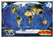
World Satellite Map. 1:39,000,000. The most accurate map of Earth's surface yet produced from satellite data. This computer-generated composite map draws from more that 500 images to give one-kilometer detail and consistent representation of natural colors.
An enlarged view of the mounted map
67-10542
World Satellite Image Map. 1:39,000,000. 44 x 30".
$12.99
67-10542L
World Satellite Image Map, laminated. 44 x 30".
$24.99
67-10542BL
World Satellite Image Map - mounted, black.
$199.95
67-10542GO
World Satellite Image Map - mounted, gold.
$199.95
67-10542WH
World Satellite Image Map - mounted, white.
$199.95
67-10542WO
World Satellite Image Map - mounted, wood-grain.
$199.95
World Explorer Map. Enjoy the accuracy and beauty of the latest world map from the cartographers at National Geographic. Map features Winkel Triple projection to reduce distortion of land masses as they near the poles. Features include charts listing largest cities by population and the largest countries in the world by land mass and population.
An enlarged view of the mounted map
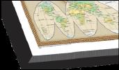
Maps of Discovery - East & West mounted set. National Geographic Maps. In 1927, famed American painter N.C. Wyeth completed a series of five murals for Hubbard Memorial Hall, the National Geographic Society's first formal library. Called "The Romance of Discovery," the murals were flanked by highly illustrated maps of the eastern and western hemispheres showing the paths taken by some of the world's most significant explorers. The eastern hemisphere map is decorated with portraits of these men charting their courses. The western hemisphere features Poseidon and a mermaid keeping watch over the oceans. These two murals have been captured on paper for everyone to enjoy.
Each plaque measures 20" x 18". Available as an east + west set mounted on wood, or as individual east or west maps, either plain paper, or laminated.
An image of the full map A detail of the map An enlarged view of the mounted map
USA Political Map - Executive Antique style. Sepia-toned antique-style map with current information. Attractive map for offices, waiting rooms, and other public places.
Sample #1 Sample #2 An enlarged view of the mounted map
62-19415
United States Political Map. 1:4,560,000. 44 x 30".
$16.99
62-19415L
Laminated. 44 x 30".
$24.99
62-19415BL
Standard size - mounted, black.
$199.95
62-19415GO
Standard size - mounted, gold.
$199.95
62-19415WH
Standard size - mounted, white.
$199.95
62-19415WO
Standard size - mounted, wood-grain.
$199.95
62-19416
United States Political Map - large size. 1:2,815,000. 69 x 48".
Afghanistan, Pakistan, and the Middle East map. National Geographic Maps. This finely detailed political map shows up-to-date country boundaries and place names, as well as beautiful shaded relief.
The map covers a broad geographic area ranging from northern Africa through the Middle East to the western edge of China and India. Includes complete coverage of Afghanistan, Pakistan, Tajikistan, Iran, Iraq, Kuwait, Syria, Israel, Jordan, Lebanon, Saudi Arabia, Qatar, Bahrain, United Arab Emirates, Yemen, Oman, Cyprus, and Eritrea.
Also includes parts of India, China, Kyrgyzstan, Uzbekistan, Turkmenistan, Azerbaijan, Armenia, Turkey, Egypt, Sudan, Ethiopia, and Djibouti. Measures 30" x 23". Scale: 1 inch = 96 miles.
An image of the full map A detail of the map A sample of the legend An enlarged view of the mounted map
France, Belgium & the Netherlands. National Geographic Map's classic wall map of France, Belgium, and the Netherlands shows political boundaries, major highways and roads, cities and towns, and a wealth of other incredibly accurate geographic detail.
Measures 30" x 23". Scale: 1 inch = 31 miles.
An image of the full map A detail from the map An enlarged view of the mounted map
Iraq & the Heart of the Middle East. National Geographic Maps. This timely two-sided map of Iraq and the Middle East features a wealth of geographic, political, natural resource, and cultural information.
The front of the map features an incredibly accurate, detailed map of political boundaries, cities and towns, major roadways, bodies of water, oil fields and pipelines, and other geographic features. Side One also includes city insets that show street plans and describe the history and cultures of Baghdad, Beirut, Damascus, and Jerusalem.
The map's reverse side shows an eye-catching satellite view of the region, as well as fact boxes that show each country's flag, population, economy, oil reserves, military strength, and include a brief historical and cultural description of each country. Three thematic maps also cover the region's historical conflicts, geographic concentrations of religions, and natural resources.
Measures 36" x 23". Scale: 1 inch = 31 miles.
Thumbnail view of the entire map. Detailed view of part of the map. An enlarged view of the mounted map
Spain & Portugal wall map. National Geographic Maps. The wall map of Spain and Portugal shows both countries in incredible detail. Also included are inset maps for major cities and surrounding islands.
Measures 33" x 22". Scale: 1 inch = 33 miles.
An image of the full map A detail from the map An enlarged view of the mounted map
 Thumbnail view of the mounting.
 Black color.
 Gold color.
 White color.
 Woodgrain color.
 An enlarged view of the mounting
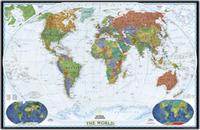
 Thumbnail of the entire map
 Sample map detail #1
 Sample map detail #2
 An image of the full map
 A detail of the map
 A sample of the legend
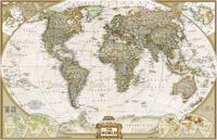


 An image of the full map
 A detail of the map
 A sample of the legend
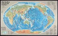
 An image of the full map
 A detail of the map
 A sample of the legend
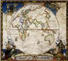
 An image of the full map
 A detail of the map
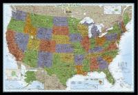
 Thumbnail image of the entire map
 Sample of the map detail
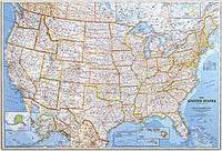
 An image of the full map
 A detail of the map
 A sample of the legend
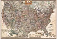
 Sample #1
 Sample #2
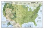
 A full image of the map
 A detail of the map
 A sample of the legend
 An image of the full map
 An image of the reverse side
 An image of the full map
 A detail of the map
 A sample of the legend
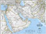
 An image of the full map
 A detail of the map
 A sample of the legend
 Thumbnail view of the entire map.
 Detailed view of part of the map.
 An image of the reverse side of the map
 A detail of the map
 A sample of the legend
 View of the front of the map.
 Detailed view of part of the map.
 Detailed view of the scale bar of the map.
 An image of the full map
 A detail of the map
 A sample of the legend
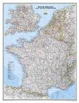
 An image of the full map
 A detail from the map
 An image of the full map
 A detail of the map
 A sample of the legend
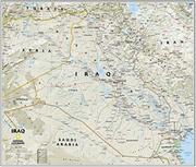
 Thumbnail view of the entire map.
 Detailed view of part of the map.
 An image of the full map
 A detail of the map
 An image of the reverse side
 A sample of the legend
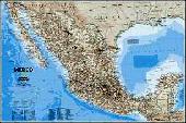
 An image of the full map
 A detail of the map
 A sample of the legend
 An image of the full map
 A detail of the map
 A sample of the legend
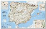
 An image of the full map
 A detail from the map
 An image of the full map
 An image of the reverse side of the map
 A detail of the map
 A sample of the legend
 An image of the full map
 A detail of the map
 A sample of the legend
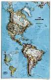
 Thumbnail view of the front of the map.
 Detailed view #1 of part of the map.
 Detailed view #2 of part of the map.
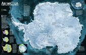
 An image of the full map
 A detail of the map
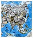
 An image of the full map
 A detail of the map
 A sample of the legend
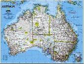
 An image of the full map
 A detail of the map
 A sample of the legend
 An image of the full map
 A detail of the map
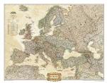
 A full image of the map
 A detail of the map
 An image of the full map
 A detail of the map
 A sample of the legend
 An image of the full map
 A detail of the map
 A sample of the legend
 An image of the full map
 A detail of the map
 An image of the front of the map
 An image of the reverse of the map
 An image of the full map
 A detail of the map
 A sample of the legend